
 Maureville
Samoëns
Gréning
Toulouse
Volx
Goudet
Méhoncourt
Saint-Hymer
Pontcarré
Maureville
Samoëns
Gréning
Toulouse
Volx
Goudet
Méhoncourt
Saint-Hymer
Pontcarré
Alain JAUME (La Table) on the map, Hayange, France
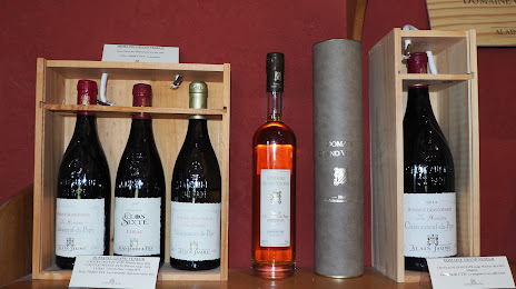
Photo
Where is located Alain JAUME (La Table)
Alain JAUME (La Table) — local attraction, which is located at Rte de Châteauneuf, 84100 Orange, France and belongs to the category — winery. Average visitor rating for this place — 4.9 (according to 24 ratings, information from open sources and relevant for 2022).
Exact location — Alain JAUME (La Table), marked on the map with a red marker.
You can get directions to Alain JAUME (La Table) on the map from your location.
What else is interesting in Hayange? You can see all the sights if you go to the city page.
Coordinates
Alain JAUME (La Table), France coordinates in decimal format: latitude — 49.33348439314973, longitude — 6.063116033193969. When converted to degrees, minutes, seconds Alain JAUME (La Table) has the following coordinates: 49°20′0.54 north latitude and 6°3′47.22 east longitude.
Nearby cities
The largest cities that are located nearby:
- Metz — 25 km
- Trier
 (Germany) — 62 km
 - Saarbrücken (Germany) — 68 km
- Nancy — 71 km
- Reims — 147 km
- Liège
 (Belgium) — 148 km
 - Strasbourg — 149 km
- Namur (Belgium) — 151 km
- Koblenz (Germany) — 157 km
- Aachen (Germany) — 160 km
- Charleroi (Belgium) — 165 km
- Maastricht
 (Netherlands) — 170 km
 - Bonn (Germany) — 172 km
- Mainz (Germany) — 172 km
- Ludwigshafen (Germany) — 172 km
- Karlsruhe (Germany) — 174 km
- Mannheim (Germany) — 174 km
- Wiesbaden (Germany) — 175 km
- Heidelberg (Germany) — 188 km
Distance to the capital
Distance to the capital (Paris) is about — 275 km.