 Warner Robins
Wantagh
Bethel
Misty Hill Farm
United States
Wakonda Beach (R33) Airport
Wilmington
Poland
Miami International Airport
Warner Robins
Wantagh
Bethel
Misty Hill Farm
United States
Wakonda Beach (R33) Airport
Wilmington
Poland
Miami International Airport
Swings-N-Things Fun Park on the map, Westlake, United States
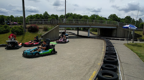
Photo
Where is located Swings-N-Things Fun Park
Swings-N-Things Fun Park — local attraction, which is located at 8501 Stearns Rd, Olmsted Falls, OH 44138, United States and belongs to the category — amusement park. Average visitor rating for this place — 4.1 (according to 1054 ratings, information from open sources and relevant for 2022).
Exact location — Swings-N-Things Fun Park, marked on the map with a red marker.
You can get directions to Swings-N-Things Fun Park on the map from your location.
What else is interesting in Westlake? You can see all the sights if you go to the city page.
Coordinates
Swings-N-Things Fun Park, United States coordinates in decimal format: latitude — 41.37056902196812, longitude — -81.94322337511987. When converted to degrees, minutes, seconds Swings-N-Things Fun Park has the following coordinates: 41°22′14.05 north latitude and -81°56′35.6 east longitude.
Nearby cities
The largest cities that are located nearby:
- Cleveland — 19 km
- Aurora — 50 km
- Akron — 53 km
- Windsor
 (Canada) — 132 km
 - Detroit — 134 km
- Toledo — 137 km
- Warren — 147 km
- Sterling Heights — 154 km
- Ann Arbor — 175 km
- London (Canada) — 178 km
- Columbus — 189 km
- Pittsburgh — 197 km
- Flint — 224 km
- Springfield — 233 km
- Kitchener (Canada) — 245 km
- Cambridge (Canada) — 247 km
- Waterloo (Canada) — 249 km
- Lansing — 257 km
- Hamilton (Canada) — 258 km
Distance to the capital
Distance to the capital (Washington) is about — 499 km.