
 Litoral Del Bajo San Juan
El Cantón de San Pablo
Juan Frío
Santa Barbara
El Juncal
Dibulla
Vereda Campo Alegre
San Pablo
Guaramito
Litoral Del Bajo San Juan
El Cantón de San Pablo
Juan Frío
Santa Barbara
El Juncal
Dibulla
Vereda Campo Alegre
San Pablo
Guaramito
Cartagena Botanical Garden "Guillermo Piñeres" on the map, Turbana, Colombia
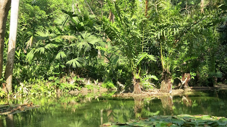
Photo
Where is located Cartagena Botanical Garden "Guillermo Piñeres"
Cartagena Botanical Garden "Guillermo Piñeres" — local attraction, which is located at Sector Matute km 9 Autopista I-90, Naranjas, Turbaco, Bolívar, Colombia and belongs to the category — botanical garden. Average visitor rating for this place — 4.6 (according to 632 ratings, information from open sources and relevant for 2022).
Exact location — Cartagena Botanical Garden "Guillermo Piñeres", marked on the map with a red marker.
You can get directions to Cartagena Botanical Garden "Guillermo Piñeres" on the map from your location.
What else is interesting in Turbana? You can see all the sights if you go to the city page.
Coordinates
Cartagena Botanical Garden "Guillermo Piñeres", Colombia coordinates in decimal format: latitude — 10.35279092176881, longitude — -75.42874727574802. When converted to degrees, minutes, seconds Cartagena Botanical Garden "Guillermo Piñeres" has the following coordinates: 10°21′10.05 north latitude and -75°25′43.49 east longitude.
Nearby cities
The largest cities that are located nearby:
- Cartagena — 18 km
- Malambo — 97 km
- Soledad — 102 km
- Barranquilla — 104 km
- Sincelejo — 107 km
- Magangué — 137 km
- Santa Marta — 171 km
- Monteria — 175 km
- Valledupar — 239 km
- Maicao — 368 km
- Barrancabermeja — 396 km
- Maracaibo
 (Venezuela) — 416 km
 - Cúcuta — 416 km
- Bucaramanga — 431 km
- Cabimas (Venezuela) — 432 km
- Giron — 433 km
- Bello — 436 km
- Floridablanca — 439 km
- Medellín — 443 km
Distance to the capital
Distance to the capital (Bogota) is about — 657 km.