
 Fuerte Olimpo
Nueva Londres
Silvio Pettirossi International Airport
José Fassardi
Capitán Mauricio José Troche
Ventiocho Kilometros de Paranambu
General Bernardino Caballero
Blas Garay
San Juan Bautista de Ñeembucú
Fuerte Olimpo
Nueva Londres
Silvio Pettirossi International Airport
José Fassardi
Capitán Mauricio José Troche
Ventiocho Kilometros de Paranambu
General Bernardino Caballero
Blas Garay
San Juan Bautista de Ñeembucú
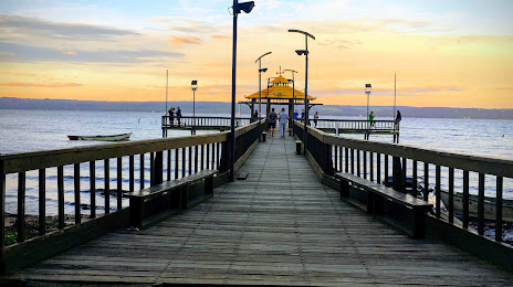
Muelle Playa de Areguá on the map, Areguá, Paraguay
Photo
Where is located Muelle Playa de Areguá
Muelle Playa de Areguá — local attraction, which is located at no data and belongs to the category — -. Average visitor rating for this place — 4.2 (according to 100 ratings, information from open sources and relevant for 2022).
Exact location — Muelle Playa de Areguá, marked on the map with a red marker.
You can get directions to Muelle Playa de Areguá on the map from your location.
What else is interesting in Areguá? You can see all the sights if you go to the city page.
Coordinates
Muelle Playa de Areguá, Paraguay coordinates in decimal format: latitude — -25.30250029897143, longitude — -57.373865140582616. When converted to degrees, minutes, seconds Muelle Playa de Areguá has the following coordinates: -25°18′9 north latitude and -57°22′25.91 east longitude.
Nearby cities
The largest cities that are located nearby:
- Luque — 8 km
- Capiata — 8 km
- San Lorenzo — 12 km
- Fernando De La Mora — 14 km
- Lambare — 20 km
- Formosa
 (Argentina) — 124 km
 - Posadas (Argentina) — 272 km
- Corrientes (Argentina) — 278 km
- Ciudad del Este — 280 km
- Foz do Iguaçu
 (Brazil) — 283 km
 - Resistencia (Argentina) — 283 km
- Cascavel (Brazil) — 398 km
- Dourados (Brazil) — 432 km
- Uruguaiana (Brazil) — 494 km
- Chapecó (Brazil) — 512 km
- Passo Fundo (Brazil) — 587 km
- Maringá (Brazil) — 593 km
- Guarapuava (Brazil) — 594 km
- Santa Maria (Brazil) — 595 km
Distance to the capital
Distance to the capital (Asuncion) is about — 26 km.