
 Belém
Maranguape
Paranaguá
Paranaguá
Monte Alegre
Alvorada de Minas
Bragança
Laguna
Ibiporã
Belém
Maranguape
Paranaguá
Paranaguá
Monte Alegre
Alvorada de Minas
Bragança
Laguna
Ibiporã
Dante Alighieri Plaza on the map, Caxias do Sul, Brazil
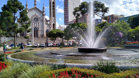
Photo
Where is located Dante Alighieri Plaza
Dante Alighieri Plaza — local attraction, which is located at R. Sinimbu, s/n - Centro, Caxias do Sul - RS, 95020-520, Brazil and belongs to the category — plaza. Average visitor rating for this place — 4.1 (according to 5657 ratings, information from open sources and relevant for 2022).
Exact location — Dante Alighieri Plaza, marked on the map with a red marker.
You can get directions to Dante Alighieri Plaza on the map from your location.
What else is interesting in Caxias do Sul? You can see all the sights if you go to the city page.
Coordinates
Dante Alighieri Plaza, Brazil coordinates in decimal format: latitude — -29.16812562396059, longitude — -51.179434075450395. When converted to degrees, minutes, seconds Dante Alighieri Plaza has the following coordinates: -29°10′5.25 north latitude and -51°10′45.96 east longitude.
Nearby cities
The largest cities that are located nearby:
- Novo Hamburgo — 58 km
- São Leopoldo — 65 km
- Canoas — 83 km
- Cachoeirinha — 87 km
- Gravataí — 88 km
- Porto Alegre — 96 km
- Viamão — 103 km
- Guaíba — 105 km
- Santa Cruz do Sul — 135 km
- Passo Fundo — 156 km
- Lages — 171 km
- Criciúma — 183 km
- Santa Maria — 260 km
- Chapecó — 268 km
- Palhoça — 298 km
- São José — 302 km
- Pelotas — 308 km
- Florianópolis — 311 km
- Blumenau — 324 km