
 Litoral Del Bajo San Juan
El Cantón de San Pablo
Juan Frío
Santa Barbara
El Juncal
Dibulla
Vereda Campo Alegre
San Pablo
Guaramito
Litoral Del Bajo San Juan
El Cantón de San Pablo
Juan Frío
Santa Barbara
El Juncal
Dibulla
Vereda Campo Alegre
San Pablo
Guaramito
Museo de Agualinda on the map, Villa Del Rosario, Colombia
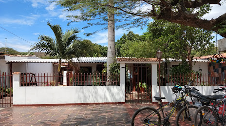
Photo
Where is located Museo de Agualinda
Museo de Agualinda — local attraction, which is located at Los Vados, Los Patios, North Santander, Colombia and belongs to the category — museum. Average visitor rating for this place — 4.5 (according to 63 ratings, information from open sources and relevant for 2022).
Exact location — Museo de Agualinda, marked on the map with a red marker.
You can get directions to Museo de Agualinda on the map from your location.
What else is interesting in Villa Del Rosario? You can see all the sights if you go to the city page.
Coordinates
Museo de Agualinda, Colombia coordinates in decimal format: latitude — 7.85020581557996, longitude — -72.47096060238694. When converted to degrees, minutes, seconds Museo de Agualinda has the following coordinates: 7°51′0.74 north latitude and -72°28′15.46 east longitude.
Nearby cities
The largest cities that are located nearby:
- Cúcuta — 6 km
- San Cristobal
 (Venezuela) — 28 km
 - Bucaramanga — 106 km
- Floridablanca — 109 km
- Giron — 114 km
- Ejido (Venezuela) — 156 km
- Merida (Venezuela) — 168 km
- Barrancabermeja — 174 km
- Sogamoso — 239 km
- Barinas (Venezuela) — 260 km
- Tunja — 271 km
- Magangué — 293 km
- Cabimas (Venezuela) — 303 km
- Valledupar — 304 km
- Maracaibo (Venezuela) — 323 km
- Guanare (Venezuela) — 328 km
- Sincelejo — 358 km
- Bello — 377 km
- Medellín — 382 km
Distance to the capital
Distance to the capital (Bogota) is about — 403 km.