
 Zelfana
Balloul
أحمد سالم كركرة
Ouargla Province
Boumaiza
Constantine
Frane
Ain Arko
Corso
Zelfana
Balloul
أحمد سالم كركرة
Ouargla Province
Boumaiza
Constantine
Frane
Ain Arko
Corso
Lac de Sidi Mohamed Benali on the map, Sidi Bel Abbes, Algeria
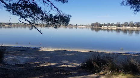
Photo
Where is located Lac de Sidi Mohamed Benali
Lac de Sidi Mohamed Benali — local attraction, which is located at no data and belongs to the category — -. Average visitor rating for this place — 4.0 (according to 67 ratings, information from open sources and relevant for 2022).
Exact location — Lac de Sidi Mohamed Benali, marked on the map with a red marker.
You can get directions to Lac de Sidi Mohamed Benali on the map from your location.
What else is interesting in Sidi Bel Abbes? You can see all the sights if you go to the city page.
Coordinates
Lac de Sidi Mohamed Benali, Algeria coordinates in decimal format: latitude — 35.24273455964846, longitude — -0.648638604801479. When converted to degrees, minutes, seconds Lac de Sidi Mohamed Benali has the following coordinates: 35°14′33.84 north latitude and -0°38′55.1 east longitude.
Nearby cities
The largest cities that are located nearby:
- Oran — 55 km
- Tlemcen — 71 km
- Saida — 82 km
- Relizane — 122 km
- Oujda
 (Morocco) — 129 km
 - Chlef — 206 km
- Nador (Morocco) — 207 km
- Almería
 (Spain) — 242 km
 - Cartagena (Spain) — 270 km
- Murcia (Spain) — 312 km
- Médéa — 325 km
- Taza (Morocco) — 327 km
- Granada (Spain) — 340 km
- Laghouat — 358 km
- Algiers — 369 km
- Taounate (Morocco) — 372 km
- Málaga (Spain) — 375 km
- Jaén (Spain) — 396 km
- Marbella (Spain) — 404 km