
 Puerto de la Duquesa
La Serna de Iguña
Pumalverde
Puentenansa
La Iglesia
Casar de Periedo
Fuengirola
Renedo de Piélagos
Villabanez
Puerto de la Duquesa
La Serna de Iguña
Pumalverde
Puentenansa
La Iglesia
Casar de Periedo
Fuengirola
Renedo de Piélagos
Villabanez
Municipal La Granja Park on the map, Burjassot, Spain
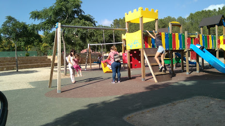
Photo
Where is located Municipal La Granja Park
Municipal La Granja Park — local attraction, which is located at Carrer de Mariano Aser, s/n, 46100 Burjassot, Valencia, Spain and belongs to the category — park. Average visitor rating for this place — 4.4 (according to 1385 ratings, information from open sources and relevant for 2022).
Exact location — Municipal La Granja Park, marked on the map with a red marker.
You can get directions to Municipal La Granja Park on the map from your location.
What else is interesting in Burjassot? You can see all the sights if you go to the city page.
Coordinates
Municipal La Granja Park, Spain coordinates in decimal format: latitude — 39.50549692858713, longitude — -0.41243297508215154. When converted to degrees, minutes, seconds Municipal La Granja Park has the following coordinates: 39°30′19.79 north latitude and -0°24′44.76 east longitude.
Nearby cities
The largest cities that are located nearby:
- Valencia — 5 km
- Albacete — 137 km
- Murcia — 179 km
- Cartagena — 214 km
- Tarragona — 225 km
- Zaragoza — 240 km
- Lleida — 248 km
- Palma — 261 km
- Alcala de Henares — 270 km
- Torrejón de Ardoz — 278 km
- Getafe — 293 km
- L'Hospitalet de Llobregat — 294 km
- Alcobendas — 294 km
- Leganés — 297 km
- Fuenlabrada — 299 km
- Alcorcón — 302 km
- Terrassa — 303 km
- Móstoles — 305 km
- Santa Coloma de Gramenet — 305 km
Distance to the capital
Distance to the capital (Madrid) is about — 298 km.