
 Puerto de la Duquesa
La Serna de Iguña
Pumalverde
Puentenansa
La Iglesia
Casar de Periedo
Fuengirola
Renedo de Piélagos
Villabanez
Puerto de la Duquesa
La Serna de Iguña
Pumalverde
Puentenansa
La Iglesia
Casar de Periedo
Fuengirola
Renedo de Piélagos
Villabanez
Castelo da Lúa on the map, Rianxo, Spain
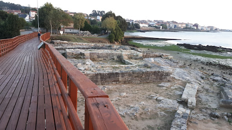
Photo
Where is located Castelo da Lúa
Castelo da Lúa — local attraction, which is located at Aldea Pazo, 167, 15920 Rianxo, A Coruña, Spain and belongs to the category — castle. Average visitor rating for this place — 4.2 (according to 152 ratings, information from open sources and relevant for 2022).
Exact location — Castelo da Lúa, marked on the map with a red marker.
You can get directions to Castelo da Lúa on the map from your location.
What else is interesting in Rianxo? You can see all the sights if you go to the city page.
Coordinates
Castelo da Lúa, Spain coordinates in decimal format: latitude — 42.66288927647721, longitude — -8.814998074984642. When converted to degrees, minutes, seconds Castelo da Lúa has the following coordinates: 42°39′46.4 north latitude and -8°48′53.99 east longitude.
Nearby cities
The largest cities that are located nearby:
- Vigo — 46 km
- A Coruña — 85 km
- Ourense — 85 km
- Braga
 (Portugal) — 126 km
 - Porto (Portugal) — 166 km
- Oviedo — 251 km
- León — 265 km
- Gijón — 271 km
- Coimbra (Portugal) — 273 km
- Salamanca — 322 km
- Valladolid — 356 km
- Santander — 412 km
- Burgos — 420 km
- Amadora (Portugal) — 432 km
- Queluz (Portugal) — 432 km
- Lisbon (Portugal) — 435 km
- Badajoz — 446 km
- Bilbao — 478 km
- Móstoles — 490 km
Distance to the capital
Distance to the capital (Madrid) is about — 493 km.