
 Puerto de la Duquesa
La Serna de Iguña
Pumalverde
Puentenansa
La Iglesia
Casar de Periedo
Fuengirola
Renedo de Piélagos
Villabanez
Puerto de la Duquesa
La Serna de Iguña
Pumalverde
Puentenansa
La Iglesia
Casar de Periedo
Fuengirola
Renedo de Piélagos
Villabanez
Yacimiento Islámico de Bofilla on the map, Massamagrell, Spain
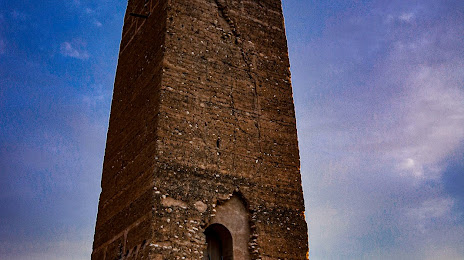
Photo
Where is located Yacimiento Islámico de Bofilla
Yacimiento Islámico de Bofilla — local attraction, which is located at 46117 Bétera, Valencia, Spain and belongs to the category — historical landmark. Average visitor rating for this place — 3.6 (according to 44 ratings, information from open sources and relevant for 2022).
Exact location — Yacimiento Islámico de Bofilla, marked on the map with a red marker.
You can get directions to Yacimiento Islámico de Bofilla on the map from your location.
What else is interesting in Massamagrell? You can see all the sights if you go to the city page.
Coordinates
Yacimiento Islámico de Bofilla, Spain coordinates in decimal format: latitude — 39.58018486864482, longitude — -0.42922087507991014. When converted to degrees, minutes, seconds Yacimiento Islámico de Bofilla has the following coordinates: 39°34′48.67 north latitude and -0°25′45.2 east longitude.
Nearby cities
The largest cities that are located nearby:
- Valencia — 12 km
- Albacete — 146 km
- Murcia — 188 km
- Tarragona — 216 km
- Cartagena — 223 km
- Zaragoza — 234 km
- Lleida — 240 km
- Palma — 254 km
- Alcala de Henares — 274 km
- Torrejón de Ardoz — 282 km
- L'Hospitalet de Llobregat — 284 km
- Terrassa — 293 km
- Santa Coloma de Gramenet — 296 km
- Alcobendas — 297 km
- Sabadell — 298 km
- Badalona — 298 km
- Getafe — 298 km
- Leganés — 302 km
- Fuenlabrada — 303 km
Distance to the capital
Distance to the capital (Madrid) is about — 294 km.