
 Puerto de la Duquesa
La Serna de Iguña
Pumalverde
Puentenansa
La Iglesia
Casar de Periedo
Fuengirola
Renedo de Piélagos
Villabanez
Puerto de la Duquesa
La Serna de Iguña
Pumalverde
Puentenansa
La Iglesia
Casar de Periedo
Fuengirola
Renedo de Piélagos
Villabanez
Parque de la Candamia on the map, Villaquilambre, Spain
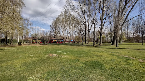
Photo
Where is located Parque de la Candamia
Parque de la Candamia — local attraction, which is located at 24005 León, Spain and belongs to the category — park. Average visitor rating for this place — 4.5 (according to 2229 ratings, information from open sources and relevant for 2022).
Exact location — Parque de la Candamia, marked on the map with a red marker.
You can get directions to Parque de la Candamia on the map from your location.
What else is interesting in Villaquilambre? You can see all the sights if you go to the city page.
Coordinates
Parque de la Candamia, Spain coordinates in decimal format: latitude — 42.602783542177434, longitude — -5.545194274986563. When converted to degrees, minutes, seconds Parque de la Candamia has the following coordinates: 42°36′10.02 north latitude and -5°32′42.7 east longitude.
Nearby cities
The largest cities that are located nearby:
- León — 5 km
- Oviedo — 83 km
- Gijón — 99 km
- Valladolid — 129 km
- Burgos — 156 km
- Santander — 167 km
- Salamanca — 185 km
- Ourense — 191 km
- Bilbao — 222 km
- Vitoria-Gasteiz — 234 km
- A Coruña — 243 km
- Logroño — 255 km
- Vigo — 263 km
- Braga
 (Portugal) — 267 km
 - Alcobendas — 283 km
- Alcorcón — 293 km
- Móstoles — 293 km
- Leganés — 297 km
- San Sebastián — 297 km
Distance to the capital
Distance to the capital (Madrid) is about — 287 km.