
 Belém
Maranguape
Paranaguá
Paranaguá
Monte Alegre
Alvorada de Minas
Bragança
Laguna
Ibiporã
Belém
Maranguape
Paranaguá
Paranaguá
Monte Alegre
Alvorada de Minas
Bragança
Laguna
Ibiporã
National Marine Park Islands of Currais on the map, Pontal do Paraná, Brazil
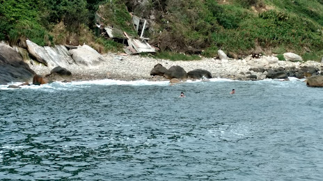
Photo
Where is located National Marine Park Islands of Currais
National Marine Park Islands of Currais — local attraction, which is located at Matinhos - State of Paraná, Brazil and belongs to the category — national park. Average visitor rating for this place — 4.8 (according to 96 ratings, information from open sources and relevant for 2022).
Exact location — National Marine Park Islands of Currais, marked on the map with a red marker.
You can get directions to National Marine Park Islands of Currais on the map from your location.
What else is interesting in Pontal do Paraná? You can see all the sights if you go to the city page.
Coordinates
National Marine Park Islands of Currais, Brazil coordinates in decimal format: latitude — -25.742930324511573, longitude — -48.35323558938182. When converted to degrees, minutes, seconds National Marine Park Islands of Currais has the following coordinates: -25°44′34.55 north latitude and -48°21′11.65 east longitude.
Nearby cities
The largest cities that are located nearby:
- Paranaguá — 21 km
- São José dos Pinhais — 75 km
- Joinville — 77 km
- Pinhais — 77 km
- Curitiba — 84 km
- Colombo — 87 km
- Araucária — 93 km
- Jaraguá do Sul — 105 km
- Itajaí — 136 km
- Blumenau — 147 km
- Florianópolis — 210 km
- São José — 213 km
- Palhoça — 216 km
- Itapetininga — 237 km
- Sorocaba — 264 km
- Praia Grande — 280 km
- Cotia — 280 km
- Itapevi — 284 km
- São Vicente — 285 km