
 Belém
Maranguape
Paranaguá
Paranaguá
Monte Alegre
Alvorada de Minas
Bragança
Laguna
Ibiporã
Belém
Maranguape
Paranaguá
Paranaguá
Monte Alegre
Alvorada de Minas
Bragança
Laguna
Ibiporã
Praia de Leste/Pontal do Paraná-PR on the map, Pontal do Paraná, Brazil
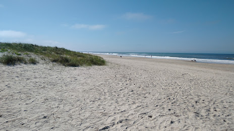
Photo
Where is located Praia de Leste/Pontal do Paraná-PR
Praia de Leste/Pontal do Paraná-PR — local attraction, which is located at no data and belongs to the category — -. Average visitor rating for this place — 4.6 (according to 2170 ratings, information from open sources and relevant for 2022).
Exact location — Praia de Leste/Pontal do Paraná-PR, marked on the map with a red marker.
You can get directions to Praia de Leste/Pontal do Paraná-PR on the map from your location.
What else is interesting in Pontal do Paraná? You can see all the sights if you go to the city page.
Coordinates
Praia de Leste/Pontal do Paraná-PR, Brazil coordinates in decimal format: latitude — -25.69978353595761, longitude — -48.47175763930759. When converted to degrees, minutes, seconds Praia de Leste/Pontal do Paraná-PR has the following coordinates: -25°41′59.22 north latitude and -48°28′18.33 east longitude.
Nearby cities
The largest cities that are located nearby:
- Paranaguá — 21 km
- São José dos Pinhais — 75 km
- Joinville — 77 km
- Pinhais — 77 km
- Curitiba — 84 km
- Colombo — 87 km
- Araucária — 93 km
- Jaraguá do Sul — 105 km
- Itajaí — 136 km
- Blumenau — 147 km
- Florianópolis — 210 km
- São José — 213 km
- Palhoça — 216 km
- Itapetininga — 237 km
- Sorocaba — 264 km
- Praia Grande — 280 km
- Cotia — 280 km
- Itapevi — 284 km
- São Vicente — 285 km