
 Puerto de la Duquesa
La Serna de Iguña
Pumalverde
Puentenansa
La Iglesia
Casar de Periedo
Fuengirola
Renedo de Piélagos
Villabanez
Puerto de la Duquesa
La Serna de Iguña
Pumalverde
Puentenansa
La Iglesia
Casar de Periedo
Fuengirola
Renedo de Piélagos
Villabanez
Monasterio de San Miguel de Lliria on the map, Benaguasil, Spain
Photo
Where is located Monasterio de San Miguel de Lliria
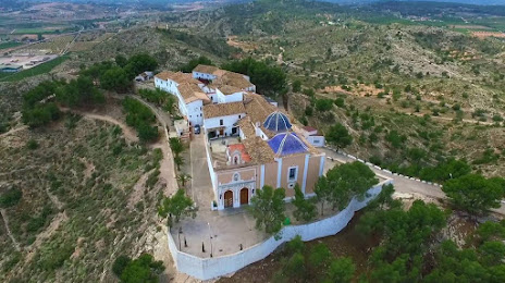
Monasterio de San Miguel de Lliria — local attraction, which is located at Cerro de San Miguel, s/n,, 46160 Llíria, Valencia, Spain and belongs to the category — monastery. Average visitor rating for this place — 4.6 (according to 297 ratings, information from open sources and relevant for 2022).
Exact location — Monasterio de San Miguel de Lliria, marked on the map with a red marker.
You can get directions to Monasterio de San Miguel de Lliria on the map from your location.
What else is interesting in Benaguasil? You can see all the sights if you go to the city page.
Coordinates
Monasterio de San Miguel de Lliria, Spain coordinates in decimal format: latitude — 39.62169139093348, longitude — -0.5991137750786691. When converted to degrees, minutes, seconds Monasterio de San Miguel de Lliria has the following coordinates: 39°37′18.09 north latitude and -0°35′56.81 east longitude.
Nearby cities
The largest cities that are located nearby:
- Valencia — 23 km
- Albacete — 127 km
- Murcia — 183 km
- Cartagena — 220 km
- Tarragona — 228 km
- Zaragoza — 229 km
- Lleida — 245 km
- Alcala de Henares — 253 km
- Torrejón de Ardoz — 261 km
- Palma — 276 km
- Getafe — 277 km
- Alcobendas — 277 km
- Leganés — 280 km
- Fuenlabrada — 282 km
- Alcorcón — 285 km
- Móstoles — 288 km
- L'Hospitalet de Llobregat — 298 km
- Terrassa — 306 km
- Santa Coloma de Gramenet — 310 km
Distance to the capital
Distance to the capital (Madrid) is about — 279 km.