
 Puerto de la Duquesa
La Serna de Iguña
Pumalverde
Puentenansa
La Iglesia
Casar de Periedo
Fuengirola
Renedo de Piélagos
Villabanez
Puerto de la Duquesa
La Serna de Iguña
Pumalverde
Puentenansa
La Iglesia
Casar de Periedo
Fuengirola
Renedo de Piélagos
Villabanez
Humedal Cerro de las Cigueñas on the map, Los Palacios y Villafranca, Spain
Photo
Where is located Humedal Cerro de las Cigueñas
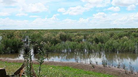
Humedal Cerro de las Cigueñas — local attraction, which is located at 41720 Los Palacios y Villafranca, Seville, Spain and belongs to the category — nature preserve. Average visitor rating for this place — 3.9 (according to 28 ratings, information from open sources and relevant for 2022).
Exact location — Humedal Cerro de las Cigueñas, marked on the map with a red marker.
You can get directions to Humedal Cerro de las Cigueñas on the map from your location.
What else is interesting in Los Palacios y Villafranca? You can see all the sights if you go to the city page.
Coordinates
Humedal Cerro de las Cigueñas, Spain coordinates in decimal format: latitude — 37.17557361116756, longitude — -5.9585159751500525. When converted to degrees, minutes, seconds Humedal Cerro de las Cigueñas has the following coordinates: 37°10′32.07 north latitude and -5°57′30.66 east longitude.
Nearby cities
The largest cities that are located nearby:
- Dos Hermanas — 14 km
- Jerez — 55 km
- Cádiz — 77 km
- Huelva — 90 km
- Marbella — 117 km
- Algeciras — 120 km
- Córdoba — 128 km
- Málaga — 139 km
- Tangier
 (Morocco) — 155 km
 - Tetouan (Morocco) — 183 km
- Jaén — 199 km
- Granada — 205 km
- Badajoz — 210 km
- Almería — 308 km
- Taounate (Morocco) — 313 km
- Lisbon
 (Portugal) — 327 km
 - Kenitra (Morocco) — 327 km
- Amadora (Portugal) — 335 km
- Queluz (Portugal) — 337 km
Distance to the capital
Distance to the capital (Madrid) is about — 410 km.