
 Belém
Maranguape
Paranaguá
Paranaguá
Monte Alegre
Alvorada de Minas
Bragança
Laguna
Ibiporã
Belém
Maranguape
Paranaguá
Paranaguá
Monte Alegre
Alvorada de Minas
Bragança
Laguna
Ibiporã
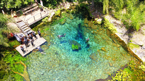
Nascente Azul Bonito-MS on the map, Bonito, Brazil
Photo
Where is located Nascente Azul Bonito-MS
Nascente Azul Bonito-MS — local attraction, which is located at Rodovia, Bonito - MS, 79290-000, Brazil and belongs to the category — tourist attraction. Average visitor rating for this place — 4.7 (according to 4126 ratings, information from open sources and relevant for 2022).
Exact location — Nascente Azul Bonito-MS, marked on the map with a red marker.
You can get directions to Nascente Azul Bonito-MS on the map from your location.
What else is interesting in Bonito? You can see all the sights if you go to the city page.
Coordinates
Nascente Azul Bonito-MS, Brazil coordinates in decimal format: latitude — -21.01514118721512, longitude — -56.511422795391915. When converted to degrees, minutes, seconds Nascente Azul Bonito-MS has the following coordinates: -21°0′54.51 north latitude and -56°30′41.12 east longitude.
Nearby cities
The largest cities that are located nearby:
- Campo Grande — 206 km
- Dourados — 210 km
- Luque
 (Paraguay) — 469 km
 - Asuncion (Paraguay) — 474 km
- Fernando De La Mora (Paraguay) — 476 km
- San Lorenzo (Paraguay) — 477 km
- Capiata (Paraguay) — 479 km
- Lambare (Paraguay) — 480 km
- Ciudad del Este (Paraguay) — 520 km
- Cascavel — 521 km
- Foz do Iguaçu — 521 km
- Maringá — 527 km
- Presidente Prudente — 533 km
- Rondonópolis — 551 km
- Apucarana — 575 km
- Formosa
 (Argentina) — 584 km
 - Várzea Grande — 607 km
- Cuiaba — 612 km
- Birigui — 633 km