
 Belém
Maranguape
Paranaguá
Paranaguá
Monte Alegre
Alvorada de Minas
Bragança
Laguna
Ibiporã
Belém
Maranguape
Paranaguá
Paranaguá
Monte Alegre
Alvorada de Minas
Bragança
Laguna
Ibiporã
Carlos Botelho State Park on the map, São Miguel Arcanjo, Brazil
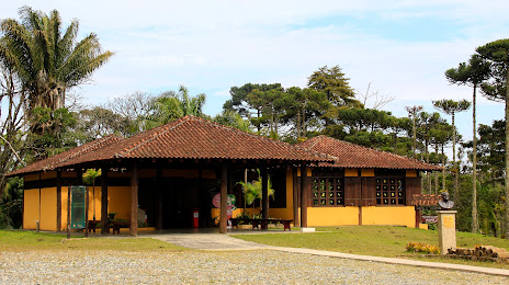
Photo
Where is located Carlos Botelho State Park
Carlos Botelho State Park — local attraction, which is located at Rodovia SP-139, km 78 - Abaitinga, Sete Barras - SP, 18230-000, Brazil and belongs to the category — state park. Average visitor rating for this place — 4.8 (according to 1880 ratings, information from open sources and relevant for 2022).
Exact location — Carlos Botelho State Park, marked on the map with a red marker.
You can get directions to Carlos Botelho State Park on the map from your location.
What else is interesting in São Miguel Arcanjo? You can see all the sights if you go to the city page.
Coordinates
Carlos Botelho State Park, Brazil coordinates in decimal format: latitude — -24.116647750104026, longitude — -47.9832688754623. When converted to degrees, minutes, seconds Carlos Botelho State Park has the following coordinates: -24°6′59.93 north latitude and -47°58′59.77 east longitude.
Nearby cities
The largest cities that are located nearby:
- Itapetininga — 32 km
- Sorocaba — 69 km
- Itu — 99 km
- Cotia — 113 km
- Itapevi — 114 km
- Jandira — 117 km
- Indaiatuba — 118 km
- Botucatu — 119 km
- Barueri — 121 km
- Carapicuiba — 123 km
- Taboão da Serra — 126 km
- Osasco — 128 km
- Piracicaba — 131 km
- Jundiaí — 135 km
- Santa Bárbara D'Oeste — 137 km
- Sumaré — 138 km
- Hortolândia — 138 km
- Várzea Paulista — 140 km
- Diadema — 141 km