
 Litoral Del Bajo San Juan
El Cantón de San Pablo
Juan Frío
Santa Barbara
El Juncal
Dibulla
Vereda Campo Alegre
San Pablo
Guaramito
Litoral Del Bajo San Juan
El Cantón de San Pablo
Juan Frío
Santa Barbara
El Juncal
Dibulla
Vereda Campo Alegre
San Pablo
Guaramito
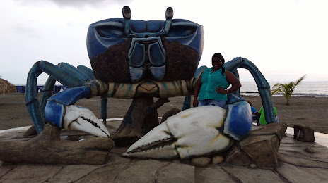
Playa Dulce, El Cangrejo on the map, Turbo, Colombia
Photo
Where is located Playa Dulce, El Cangrejo
Playa Dulce, El Cangrejo — local attraction, which is located at a 106-419,, Cra 1 / La Playa #1061, Turbo, Antioquia, Colombia and belongs to the category — beach volleyball court. Average visitor rating for this place — 4.4 (according to 127 ratings, information from open sources and relevant for 2022).
Exact location — Playa Dulce, El Cangrejo, marked on the map with a red marker.
You can get directions to Playa Dulce, El Cangrejo on the map from your location.
What else is interesting in Turbo? You can see all the sights if you go to the city page.
Coordinates
Playa Dulce, El Cangrejo, Colombia coordinates in decimal format: latitude — 8.096645595669695, longitude — -76.73994347567047. When converted to degrees, minutes, seconds Playa Dulce, El Cangrejo has the following coordinates: 8°5′47.92 north latitude and -76°44′23.8 east longitude.
Nearby cities
The largest cities that are located nearby:
- Monteria — 118 km
- Sincelejo — 198 km
- Bello — 233 km
- Medellín — 239 km
- Itagüi — 246 km
- Envigado — 247 km
- Magangué — 250 km
- Cartagena — 288 km
- San Miguelito
 (Panama) — 319 km
 - Panama (Panama) — 320 km
- Barrancabermeja — 336 km
- Manizales — 360 km
- Malambo — 372 km
- Soledad — 378 km
- Dos Quebradas — 379 km
- Pereira — 380 km
- Cartago — 381 km
- Barranquilla — 381 km
- Giron — 407 km
Distance to the capital
Distance to the capital (Bogota) is about — 488 km.