
 Puerto de la Duquesa
La Serna de Iguña
Pumalverde
Puentenansa
La Iglesia
Casar de Periedo
Fuengirola
Renedo de Piélagos
Villabanez
Puerto de la Duquesa
La Serna de Iguña
Pumalverde
Puentenansa
La Iglesia
Casar de Periedo
Fuengirola
Renedo de Piélagos
Villabanez
Penya del Moro on the map, Sant Feliu de Llobregat, Spain
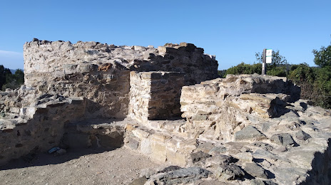
Photo
Where is located Penya del Moro
Penya del Moro — local attraction, which is located at 08960 Sant Just Desvern, Barcelona, Spain and belongs to the category — historical landmark. Average visitor rating for this place — 4.5 (according to 384 ratings, information from open sources and relevant for 2022).
Exact location — Penya del Moro, marked on the map with a red marker.
You can get directions to Penya del Moro on the map from your location.
What else is interesting in Sant Feliu de Llobregat? You can see all the sights if you go to the city page.
Coordinates
Penya del Moro, Spain coordinates in decimal format: latitude — 41.39681366231444, longitude — 2.068896824975493. When converted to degrees, minutes, seconds Penya del Moro has the following coordinates: 41°23′48.53 north latitude and 2°4′8.03 east longitude.
Nearby cities
The largest cities that are located nearby:
- L'Hospitalet de Llobregat — 6 km
- Santa Coloma de Gramenet — 15 km
- Badalona — 18 km
- Sabadell — 19 km
- Terrassa — 20 km
- Mataró — 37 km
- Tarragona — 73 km
- Lleida — 121 km
- Perpignan
 (France) — 160 km
 - Palma — 207 km
- Zaragoza — 245 km
- Toulouse (France) — 250 km
- Montpellier (France) — 286 km
- Valencia — 296 km
- Nimes (France) — 328 km
- Pamplona — 339 km
- Marseille (France) — 341 km
- Aix-en-Provence (France) — 361 km
- Toulon (France) — 367 km
Distance to the capital
Distance to the capital (Madrid) is about — 497 km.