
 Litoral Del Bajo San Juan
El Cantón de San Pablo
Juan Frío
Santa Barbara
El Juncal
Dibulla
Vereda Campo Alegre
San Pablo
Guaramito
Litoral Del Bajo San Juan
El Cantón de San Pablo
Juan Frío
Santa Barbara
El Juncal
Dibulla
Vereda Campo Alegre
San Pablo
Guaramito
Piedra de Bolivar on the map, Mompos, Colombia
Photo
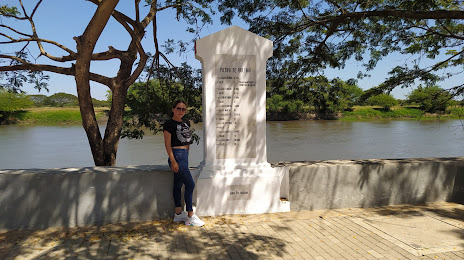
Where is located Piedra de Bolivar
Piedra de Bolivar — local attraction, which is located at Faltriquera, Bolívar, Mompós, Bolívar, Colombia and belongs to the category — historical place. Average visitor rating for this place — 4.7 (according to 141 rating, information from open sources and relevant for 2022).
Exact location — Piedra de Bolivar, marked on the map with a red marker.
You can get directions to Piedra de Bolivar on the map from your location.
What else is interesting in Mompos? You can see all the sights if you go to the city page.
Coordinates
Piedra de Bolivar, Colombia coordinates in decimal format: latitude — 9.240625440159317, longitude — -74.42275627566231. When converted to degrees, minutes, seconds Piedra de Bolivar has the following coordinates: 9°14′26.25 north latitude and -74°25′21.92 east longitude.
Nearby cities
The largest cities that are located nearby:
- Magangué — 36 km
- Sincelejo — 106 km
- Monteria — 168 km
- Cartagena — 177 km
- Malambo — 183 km
- Valledupar — 187 km
- Soledad — 189 km
- Barranquilla — 196 km
- Santa Marta — 223 km
- Barrancabermeja — 249 km
- Cúcuta — 258 km
- Bucaramanga — 273 km
- Giron — 276 km
- Floridablanca — 282 km
- San Cristobal
 (Venezuela) — 290 km
 - Maicao — 335 km
- Maracaibo (Venezuela) — 340 km
- Bello — 344 km
- Cabimas (Venezuela) — 346 km
Distance to the capital
Distance to the capital (Bogota) is about — 518 km.