
 Belém
Maranguape
Paranaguá
Paranaguá
Monte Alegre
Alvorada de Minas
Bragança
Laguna
Ibiporã
Belém
Maranguape
Paranaguá
Paranaguá
Monte Alegre
Alvorada de Minas
Bragança
Laguna
Ibiporã
Floresta Nacional de Palmares on the map, Altos, Brazil
Photo
Where is located Floresta Nacional de Palmares
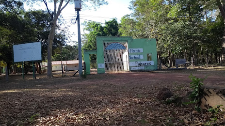
Floresta Nacional de Palmares — local attraction, which is located at BR-343, Altos - PI, 64290-000, Brazil and belongs to the category — national forest. Average visitor rating for this place — 4.4 (according to 61 rating, information from open sources and relevant for 2022).
Exact location — Floresta Nacional de Palmares, marked on the map with a red marker.
You can get directions to Floresta Nacional de Palmares on the map from your location.
What else is interesting in Altos? You can see all the sights if you go to the city page.
Coordinates
Floresta Nacional de Palmares, Brazil coordinates in decimal format: latitude — -5.0493872109790265, longitude — -42.596598534934174. When converted to degrees, minutes, seconds Floresta Nacional de Palmares has the following coordinates: -5°2′57.79 north latitude and -42°35′47.75 east longitude.
Nearby cities
The largest cities that are located nearby:
- Teresina — 38 km
- Timon — 41 km
- Caxias — 101 km
- Parnaíba — 248 km
- São Luís — 342 km
- Juazeiro do Norte — 422 km
- Maracanaú — 442 km
- Caucaia — 444 km
- Fortaleza — 458 km
- Petrolina — 526 km
- Imperatriz — 554 km
- Mossoro — 563 km
- Araguaína — 673 km
- Castanhal — 731 km
- Marabá — 735 km
- Campina Grande — 762 km
- Ananindeua — 770 km
- Belém — 775 km
- Caruaru — 796 km