
 Belém
Maranguape
Paranaguá
Paranaguá
Monte Alegre
Alvorada de Minas
Bragança
Laguna
Ibiporã
Belém
Maranguape
Paranaguá
Paranaguá
Monte Alegre
Alvorada de Minas
Bragança
Laguna
Ibiporã
Intervales State Park (Parque Estadual Intervales) on the map, Sete Barras, Brazil
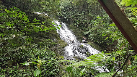
Photo
Where is located Intervales State Park (Parque Estadual Intervales)
Intervales State Park (Parque Estadual Intervales) — local attraction, which is located at Estrada Municipal, km 25 s/n Zona Rural, Ribeirão Grande - SP, 18315-000, Brazil and belongs to the category — state park. Average visitor rating for this place — 4.7 (according to 345 ratings, information from open sources and relevant for 2022).
Exact location — Intervales State Park (Parque Estadual Intervales), marked on the map with a red marker.
You can get directions to Intervales State Park (Parque Estadual Intervales) on the map from your location.
What else is interesting in Sete Barras? You can see all the sights if you go to the city page.
Coordinates
Intervales State Park (Parque Estadual Intervales), Brazil coordinates in decimal format: latitude — -24.308819083598756, longitude — -48.2736542754586. When converted to degrees, minutes, seconds Intervales State Park (Parque Estadual Intervales) has the following coordinates: -24°18′31.75 north latitude and -48°16′25.16 east longitude.
Nearby cities
The largest cities that are located nearby:
- Itapetininga — 89 km
- Sorocaba — 109 km
- Cotia — 134 km
- Itapevi — 137 km
- Paranaguá — 139 km
- Itu — 141 km
- Jandira — 141 km
- Taboão da Serra — 143 km
- Barueri — 144 km
- Carapicuiba — 146 km
- Osasco — 149 km
- Diadema — 153 km
- São Bernardo do Campo — 158 km
- Praia Grande — 159 km
- São Paulo — 160 km
- Saint Andrew — 161 km
- Indaiatuba — 161 km
- Cubatão — 161 km
- São Vicente — 162 km