 Warner Robins
Wantagh
Bethel
Misty Hill Farm
United States
Wakonda Beach (R33) Airport
Wilmington
Poland
Miami International Airport
Warner Robins
Wantagh
Bethel
Misty Hill Farm
United States
Wakonda Beach (R33) Airport
Wilmington
Poland
Miami International Airport
Beth Sholom Synagogue on the map, Philadelphia, United States
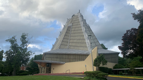
Photo
Where is located Beth Sholom Synagogue
Beth Sholom Synagogue — local attraction, which is located at 8231 Old York Rd, Elkins Park, PA 19027, United States and belongs to the category — synagogue. Average visitor rating for this place — 4.8 (according to 108 ratings, information from open sources and relevant for 2022).
Exact location — Beth Sholom Synagogue, marked on the map with a red marker.
You can get directions to Beth Sholom Synagogue on the map from your location.
What else is interesting in Philadelphia? You can see all the sights if you go to the city page.
Coordinates
Beth Sholom Synagogue, United States coordinates in decimal format: latitude — 40.0821701395171, longitude — -75.12650257506483. When converted to degrees, minutes, seconds Beth Sholom Synagogue has the following coordinates: 40°4′55.81 north latitude and -75°7′35.41 east longitude.
Nearby cities
The largest cities that are located nearby:
- Allentown — 77 km
- Toms River — 82 km
- Edison — 89 km
- Elizabeth — 112 km
- Newark — 120 km
- Brooklyn — 128 km
- New York — 128 km
- Paterson — 135 km
- Baltimore — 144 km
- Yonkers — 151 km
- Stamford — 182 km
- Alexandria — 206 km
- Bridgeport — 213 km
- New Haven — 239 km
- Waterbury — 249 km
- Hartford — 286 km
- Springfield — 318 km
- Richmond — 333 km
- Hampton — 340 km
Distance to the capital
Distance to the capital (Washington) is about — 210 km.