 Warner Robins
Wantagh
Bethel
Misty Hill Farm
United States
Wakonda Beach (R33) Airport
Wilmington
Poland
Miami International Airport
Warner Robins
Wantagh
Bethel
Misty Hill Farm
United States
Wakonda Beach (R33) Airport
Wilmington
Poland
Miami International Airport
Inner Harbor on the map, Syracuse, United States
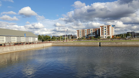
Photo
Where is located Inner Harbor
Inner Harbor — local attraction, which is located at 408-456 Solar St, Syracuse, NY 13204, United States and belongs to the category — park. Average visitor rating for this place — 4.3 (according to 671 rating, information from open sources and relevant for 2022).
Exact location — Inner Harbor, marked on the map with a red marker.
You can get directions to Inner Harbor on the map from your location.
What else is interesting in Syracuse? You can see all the sights if you go to the city page.
Coordinates
Inner Harbor, United States coordinates in decimal format: latitude — 43.06133720484349, longitude — -76.16296807497196. When converted to degrees, minutes, seconds Inner Harbor has the following coordinates: 43°3′40.81 north latitude and -76°9′46.69 east longitude.
Nearby cities
The largest cities that are located nearby:
- Rochester — 119 km
- Kingston
 (Canada) — 134 km
 - Amherst — 214 km
- Boston — 216 km
- Buffalo — 222 km
- Oshawa (Canada) — 236 km
- Whitby (Canada) — 242 km
- Saint Catharines (Canada) — 250 km
- Ottawa (Canada) — 265 km
- Toronto (Canada) — 267 km
- Markham (Canada) — 270 km
- Gatineau (Canada) — 271 km
- Allentown — 275 km
- Richmond Hill (Canada) — 278 km
- Vaughan (Canada) — 282 km
- Mississauga (Canada) — 286 km
- Paterson — 288 km
- Oakville (Canada) — 288 km
- Burlington (Canada) — 295 km
Distance to the capital
Distance to the capital (Washington) is about — 468 km.