 Warner Robins
Wantagh
Bethel
Misty Hill Farm
United States
Wakonda Beach (R33) Airport
Wilmington
Poland
Miami International Airport
Warner Robins
Wantagh
Bethel
Misty Hill Farm
United States
Wakonda Beach (R33) Airport
Wilmington
Poland
Miami International Airport
Veterans Memorial Park on the map, Saint Clair Shores, United States
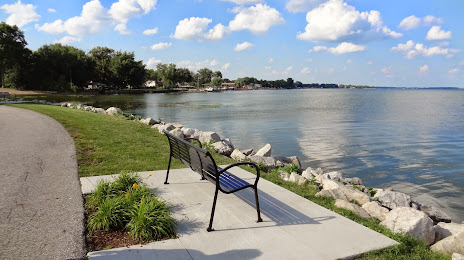
Photo
Where is located Veterans Memorial Park
Veterans Memorial Park — local attraction, which is located at 32400 Jefferson Ave, St Clair Shores, MI 48082, United States and belongs to the category — city park. Average visitor rating for this place — 4.6 (according to 1087 ratings, information from open sources and relevant for 2022).
Exact location — Veterans Memorial Park, marked on the map with a red marker.
You can get directions to Veterans Memorial Park on the map from your location.
What else is interesting in Saint Clair Shores? You can see all the sights if you go to the city page.
Coordinates
Veterans Memorial Park, United States coordinates in decimal format: latitude — 42.41446893533805, longitude — -82.87390595685562. When converted to degrees, minutes, seconds Veterans Memorial Park has the following coordinates: 42°24′52.09 north latitude and -82°52′26.06 east longitude.
Nearby cities
The largest cities that are located nearby:
- Warren — 10 km
- Sterling Heights — 14 km
- Detroit — 22 km
- Windsor
 (Canada) — 23 km
 - Ann Arbor — 73 km
- Flint — 86 km
- Toledo — 107 km
- Lansing — 137 km
- London (Canada) — 144 km
- Cleveland — 149 km
- Aurora — 183 km
- Akron — 194 km
- Waterloo (Canada) — 219 km
- Kitchener (Canada) — 219 km
- Cambridge (Canada) — 228 km
- Grand Rapids — 230 km
- Guelph (Canada) — 242 km
- Fort Wayne — 244 km
- Hamilton (Canada) — 258 km
Distance to the capital
Distance to the capital (Washington) is about — 628 km.