 Warner Robins
Wantagh
Bethel
Misty Hill Farm
United States
Wakonda Beach (R33) Airport
Wilmington
Poland
Miami International Airport
Warner Robins
Wantagh
Bethel
Misty Hill Farm
United States
Wakonda Beach (R33) Airport
Wilmington
Poland
Miami International Airport
Kwahadi Museum of the American Indian on the map, Amarillo, United States
Photo
Where is located Kwahadi Museum of the American Indian
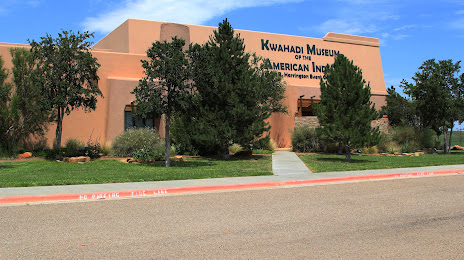
Kwahadi Museum of the American Indian — local attraction, which is located at 9151 I-40, Amarillo, TX 79118, United States and belongs to the category — museum. Average visitor rating for this place — 4.6 (according to 120 ratings, information from open sources and relevant for 2022).
Exact location — Kwahadi Museum of the American Indian, marked on the map with a red marker.
You can get directions to Kwahadi Museum of the American Indian on the map from your location.
What else is interesting in Amarillo? You can see all the sights if you go to the city page.
Coordinates
Kwahadi Museum of the American Indian, United States coordinates in decimal format: latitude — 35.19373922571896, longitude — -101.73398987520507. When converted to degrees, minutes, seconds Kwahadi Museum of the American Indian has the following coordinates: 35°11′37.46 north latitude and -101°44′2.36 east longitude.
Nearby cities
The largest cities that are located nearby:
- Lubbock — 182 km
- Wichita Falls — 339 km
- Abilene — 364 km
- Oklahoma City — 389 km
- Norman — 397 km
- Pueblo — 413 km
- Albuquerque — 432 km
- Valencia — 445 km
- Colorado Springs — 475 km
- Wichita — 479 km
- Denton — 488 km
- Fort Worth — 499 km
- Frisco — 517 km
- Arlington — 518 km
- Carrollton — 521 km
- Irving — 526 km
- Grand Prairie — 526 km
- Tulsa — 531 km
- Plano — 534 km
Distance to the capital
Distance to the capital (Washington) is about — 2224 km.