 Warner Robins
Wantagh
Bethel
Misty Hill Farm
United States
Wakonda Beach (R33) Airport
Wilmington
Poland
Miami International Airport
Warner Robins
Wantagh
Bethel
Misty Hill Farm
United States
Wakonda Beach (R33) Airport
Wilmington
Poland
Miami International Airport
Edward "Ted" and Pat Jones-Confluence Point State Park on the map, O'Fallon, United States
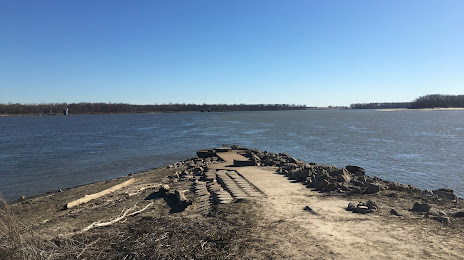
Photo
Where is located Edward "Ted" and Pat Jones-Confluence Point State Park
Edward "Ted" and Pat Jones-Confluence Point State Park — local attraction, which is located at 1000 Riverlands Way, West Alton, MO 63386, United States and belongs to the category — county park. Average visitor rating for this place — 4.2 (according to 95 ratings, information from open sources and relevant for 2022).
Exact location — Edward "Ted" and Pat Jones-Confluence Point State Park, marked on the map with a red marker.
You can get directions to Edward "Ted" and Pat Jones-Confluence Point State Park on the map from your location.
What else is interesting in O'Fallon? You can see all the sights if you go to the city page.
Coordinates
Edward "Ted" and Pat Jones-Confluence Point State Park, United States coordinates in decimal format: latitude — 38.83612677242165, longitude — -90.12616567510203. When converted to degrees, minutes, seconds Edward "Ted" and Pat Jones-Confluence Point State Park has the following coordinates: 38°50′10.06 north latitude and -90°7′34.2 east longitude.
Nearby cities
The largest cities that are located nearby:
- Saint Louis — 48 km
- Peoria — 228 km
- Evansville — 288 km
- Springfield — 289 km
- Independence — 320 km
- North Kansas City — 334 km
- Kansas City — 334 km
- Overland Park — 342 km
- Olathe — 355 km
- Joliet — 370 km
- Aurora — 381 km
- Naperville — 387 km
- Clarksville — 389 km
- Des Moines — 391 km
- Indianapolis — 400 km
- Rockford — 405 km
- Memphis — 409 km
- Chicago — 423 km
- Topeka — 429 km
Distance to the capital
Distance to the capital (Washington) is about — 1133 km.