 Warner Robins
Wantagh
Bethel
Misty Hill Farm
United States
Wakonda Beach (R33) Airport
Wilmington
Poland
Miami International Airport
Warner Robins
Wantagh
Bethel
Misty Hill Farm
United States
Wakonda Beach (R33) Airport
Wilmington
Poland
Miami International Airport
Historic Huntley Plantation on the map, Alexandria, United States
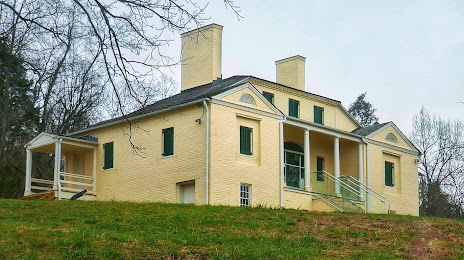
Photo
Where is located Historic Huntley Plantation
Historic Huntley Plantation — local attraction, which is located at 6918 County Rd 723, Alexandria, VA 22306, United States and belongs to the category — historical landmark. Average visitor rating for this place — 5.0 (according to 21 rating, information from open sources and relevant for 2022).
Exact location — Historic Huntley Plantation, marked on the map with a red marker.
You can get directions to Historic Huntley Plantation on the map from your location.
What else is interesting in Alexandria? You can see all the sights if you go to the city page.
Coordinates
Historic Huntley Plantation, United States coordinates in decimal format: latitude — 38.765715635254665, longitude — -77.09507437510409. When converted to degrees, minutes, seconds Historic Huntley Plantation has the following coordinates: 38°45′56.58 north latitude and -77°5′42.27 east longitude.
Nearby cities
The largest cities that are located nearby:
- Baltimore — 65 km
- Richmond — 144 km
- Philadelphia — 204 km
- Hampton — 206 km
- Norfolk — 226 km
- Chesapeake — 235 km
- Virginia Beach — 236 km
- Allentown — 238 km
- Toms River — 273 km
- Edison — 291 km
- Pittsburgh — 307 km
- Elizabeth — 314 km
- Newark — 322 km
- Brooklyn — 330 km
- New York — 331 km
- Paterson — 335 km
- Durham — 352 km
- Yonkers — 353 km
- Raleigh — 364 km
Distance to the capital
Distance to the capital (Washington) is about — 17 km.