 Warner Robins
Wantagh
Bethel
Misty Hill Farm
United States
Wakonda Beach (R33) Airport
Wilmington
Poland
Miami International Airport
Warner Robins
Wantagh
Bethel
Misty Hill Farm
United States
Wakonda Beach (R33) Airport
Wilmington
Poland
Miami International Airport
Cahaba River Trail & Canoe drop on the map, Birmingham, United States
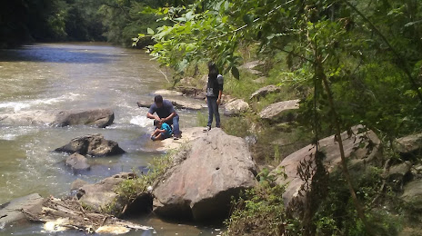
Photo
Where is located Cahaba River Trail & Canoe drop
Cahaba River Trail & Canoe drop — local attraction, which is located at 2171 Grants Mill Rd, Birmingham, AL 35210, United States and belongs to the category — country park. Average visitor rating for this place — 4.7 (according to 104 ratings, information from open sources and relevant for 2022).
Exact location — Cahaba River Trail & Canoe drop, marked on the map with a red marker.
You can get directions to Cahaba River Trail & Canoe drop on the map from your location.
What else is interesting in Birmingham? You can see all the sights if you go to the city page.
Coordinates
Cahaba River Trail & Canoe drop, United States coordinates in decimal format: latitude — 33.312237440836846, longitude — -86.8459990901663. When converted to degrees, minutes, seconds Cahaba River Trail & Canoe drop has the following coordinates: 33°18′44.05 north latitude and -86°50′45.6 east longitude.
Nearby cities
The largest cities that are located nearby:
- Huntsville — 135 km
- Montgomery — 136 km
- Chattanooga — 216 km
- Atlanta — 223 km
- Nashville — 292 km
- Mobile — 334 km
- Clarksville — 336 km
- Jackson — 344 km
- Memphis — 344 km
- Knoxville — 373 km
- Tallahassee — 417 km
- Evansville — 497 km
- New Orleans — 504 km
- Metairie — 506 km
- Little Rock — 517 km
- Louisville — 531 km
- Columbia — 531 km
- Baton Rouge — 534 km
- Savannah — 557 km
Distance to the capital
Distance to the capital (Washington) is about — 1078 km.