 Warner Robins
Wantagh
Bethel
Misty Hill Farm
United States
Wakonda Beach (R33) Airport
Wilmington
Poland
Miami International Airport
Warner Robins
Wantagh
Bethel
Misty Hill Farm
United States
Wakonda Beach (R33) Airport
Wilmington
Poland
Miami International Airport
Mathias Ham Historic Site on the map, Dubuque, United States
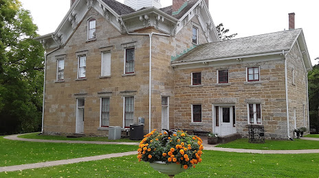
Photo
Where is located Mathias Ham Historic Site
Mathias Ham Historic Site — local attraction, which is located at 2241 Lincoln Ave, Dubuque, IA 52001, United States and belongs to the category — museum. Average visitor rating for this place — 4.5 (according to 81 rating, information from open sources and relevant for 2022).
Exact location — Mathias Ham Historic Site, marked on the map with a red marker.
You can get directions to Mathias Ham Historic Site on the map from your location.
What else is interesting in Dubuque? You can see all the sights if you go to the city page.
Coordinates
Mathias Ham Historic Site, United States coordinates in decimal format: latitude — 42.53131670144525, longitude — -90.65072377498885. When converted to degrees, minutes, seconds Mathias Ham Historic Site has the following coordinates: 42°31′52.74 north latitude and -90°39′2.61 east longitude.
Nearby cities
The largest cities that are located nearby:
- Madison — 120 km
- Rockford — 131 km
- Aurora — 210 km
- Peoria — 219 km
- Naperville — 223 km
- Milwaukee — 231 km
- Joliet — 239 km
- Chicago — 259 km
- Des Moines — 263 km
- Green Bay — 305 km
- Saint Paul — 331 km
- Minneapolis — 341 km
- South Bend — 376 km
- Grand Rapids — 407 km
- Saint Louis — 430 km
- Omaha — 464 km
- Fort Wayne — 487 km
- Indianapolis — 488 km
- Independence — 496 km
Distance to the capital
Distance to the capital (Washington) is about — 1215 km.