 Warner Robins
Wantagh
Bethel
Misty Hill Farm
United States
Wakonda Beach (R33) Airport
Wilmington
Poland
Miami International Airport
Warner Robins
Wantagh
Bethel
Misty Hill Farm
United States
Wakonda Beach (R33) Airport
Wilmington
Poland
Miami International Airport
Pearsall Park on the map, San Antonio, United States
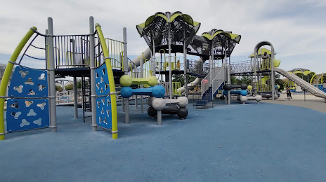
Photo
Where is located Pearsall Park
Pearsall Park — local attraction, which is located at 4838 Old Pearsall Rd, San Antonio, TX 78242, United States and belongs to the category — park. Average visitor rating for this place — 4.7 (according to 3264 ratings, information from open sources and relevant for 2022).
Exact location — Pearsall Park, marked on the map with a red marker.
You can get directions to Pearsall Park on the map from your location.
What else is interesting in San Antonio? You can see all the sights if you go to the city page.
Coordinates
Pearsall Park, United States coordinates in decimal format: latitude — 29.35909917077587, longitude — -98.5958674053928. When converted to degrees, minutes, seconds Pearsall Park has the following coordinates: 29°21′32.76 north latitude and -98°35′45.12 east longitude.
Nearby cities
The largest cities that are located nearby:
- Austin — 118 km
- Killeen — 201 km
- Corpus Christi — 209 km
- Piedras Negras
 (Mexico) — 212 km
 - Laredo — 231 km
- Ciudad Acuna (Mexico) — 237 km
- Nuevo Laredo (Mexico) — 239 km
- Waco — 267 km
- Houston — 302 km
- Abilene — 354 km
- McAllen — 357 km
- Reynosa (Mexico) — 369 km
- Fort Worth — 384 km
- Arlington — 388 km
- Grand Prairie — 393 km
- Monclova (Mexico) — 401 km
- Irving — 401 km
- Brownsville — 402 km
- Dallas — 403 km
Distance to the capital
Distance to the capital (Washington) is about — 2243 km.