 Warner Robins
Wantagh
Bethel
Misty Hill Farm
United States
Wakonda Beach (R33) Airport
Wilmington
Poland
Miami International Airport
Warner Robins
Wantagh
Bethel
Misty Hill Farm
United States
Wakonda Beach (R33) Airport
Wilmington
Poland
Miami International Airport
National Historic Trails Interpretive Center on the map, Casper, United States
Photo
Where is located National Historic Trails Interpretive Center
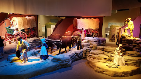
National Historic Trails Interpretive Center — local attraction, which is located at 1501 N Poplar St, Casper, WY 82601, United States and belongs to the category — history museum. Average visitor rating for this place — 4.9 (according to 471 rating, information from open sources and relevant for 2022).
Exact location — National Historic Trails Interpretive Center, marked on the map with a red marker.
You can get directions to National Historic Trails Interpretive Center on the map from your location.
What else is interesting in Casper? You can see all the sights if you go to the city page.
Coordinates
National Historic Trails Interpretive Center, United States coordinates in decimal format: latitude — 42.866287592838574, longitude — -106.33723037497818. When converted to degrees, minutes, seconds National Historic Trails Interpretive Center has the following coordinates: 42°51′58.64 north latitude and -106°20′14.03 east longitude.
Nearby cities
The largest cities that are located nearby:
- Fort Collins — 273 km
- Thornton — 351 km
- Westminster — 352 km
- Arvada — 354 km
- Denver — 364 km
- Lakewood — 365 km
- Aurora — 369 km
- Colorado Springs — 464 km
- Salt Lake City — 522 km
- Pueblo — 531 km
- West Valley City — 534 km
- West Jordan — 534 km
- Provo — 537 km
- Sioux Falls — 772 km
- Boise — 797 km
- Lincoln — 837 km
- Regina
 (Canada) — 847 km
 - Albuquerque — 861 km
- Omaha — 876 km
Distance to the capital
Distance to the capital (Washington) is about — 2490 km.