 Warner Robins
Wantagh
Bethel
Misty Hill Farm
United States
Wakonda Beach (R33) Airport
Wilmington
Poland
Miami International Airport
Warner Robins
Wantagh
Bethel
Misty Hill Farm
United States
Wakonda Beach (R33) Airport
Wilmington
Poland
Miami International Airport
Rochester Museum & Science Center on the map, Rochester, United States
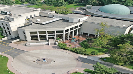
Photo
Where is located Rochester Museum & Science Center
Rochester Museum & Science Center — local attraction, which is located at 657 East Ave, Rochester, NY 14607, United States and belongs to the category — museum. Average visitor rating for this place — 4.5 (according to 328 ratings, information from open sources and relevant for 2022).
Exact location — Rochester Museum & Science Center, marked on the map with a red marker.
You can get directions to Rochester Museum & Science Center on the map from your location.
What else is interesting in Rochester? You can see all the sights if you go to the city page.
Coordinates
Rochester Museum & Science Center, United States coordinates in decimal format: latitude — 43.1850336506271, longitude — -77.61846093773399. When converted to degrees, minutes, seconds Rochester Museum & Science Center has the following coordinates: 43°11′6.12 north latitude and -77°37′6.46 east longitude.
Nearby cities
The largest cities that are located nearby:
- Amherst — 98 km
- Buffalo — 107 km
- Boston — 109 km
- Syracuse — 119 km
- Oshawa
 (Canada) — 129 km
 - Saint Catharines (Canada) — 132 km
- Whitby (Canada) — 134 km
- Kingston (Canada) — 148 km
- Toronto (Canada) — 152 km
- Markham (Canada) — 158 km
- Richmond Hill (Canada) — 166 km
- Vaughan (Canada) — 169 km
- Mississauga (Canada) — 170 km
- Oakville (Canada) — 170 km
- Burlington (Canada) — 177 km
- Hamilton (Canada) — 182 km
- Brampton (Canada) — 183 km
- Barrie (Canada) — 213 km
- Guelph (Canada) — 216 km
Distance to the capital
Distance to the capital (Washington) is about — 478 km.