 Warner Robins
Wantagh
Bethel
Misty Hill Farm
United States
Wakonda Beach (R33) Airport
Wilmington
Poland
Miami International Airport
Warner Robins
Wantagh
Bethel
Misty Hill Farm
United States
Wakonda Beach (R33) Airport
Wilmington
Poland
Miami International Airport
Fort Des Moines Park on the map, West Des Moines, United States
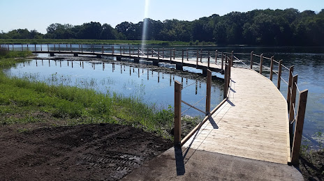
Photo
Where is located Fort Des Moines Park
Fort Des Moines Park — local attraction, which is located at 7200 SE 5th St, Des Moines, IA 50315, United States and belongs to the category — park. Average visitor rating for this place — 4.6 (according to 367 ratings, information from open sources and relevant for 2022).
Exact location — Fort Des Moines Park, marked on the map with a red marker.
You can get directions to Fort Des Moines Park on the map from your location.
What else is interesting in West Des Moines? You can see all the sights if you go to the city page.
Coordinates
Fort Des Moines Park, United States coordinates in decimal format: latitude — 41.564273078212366, longitude — -93.61064407243906. When converted to degrees, minutes, seconds Fort Des Moines Park has the following coordinates: 41°33′51.38 north latitude and -93°36′38.32 east longitude.
Nearby cities
The largest cities that are located nearby:
- Des Moines — 9 km
- Omaha — 193 km
- Lincoln — 262 km
- North Kansas City — 279 km
- Independence — 281 km
- Kansas City — 284 km
- Overland Park — 299 km
- Olathe — 313 km
- Sioux Falls — 325 km
- Topeka — 326 km
- Peoria — 359 km
- Saint Paul — 376 km
- Minneapolis — 378 km
- Madison — 385 km
- Rockford — 385 km
- Aurora — 445 km
- Saint Louis — 445 km
- Naperville — 459 km
- Joliet — 466 km
Distance to the capital
Distance to the capital (Washington) is about — 1436 km.