 Warner Robins
Wantagh
Bethel
Misty Hill Farm
United States
Wakonda Beach (R33) Airport
Wilmington
Poland
Miami International Airport
Warner Robins
Wantagh
Bethel
Misty Hill Farm
United States
Wakonda Beach (R33) Airport
Wilmington
Poland
Miami International Airport
Crowley's Ridge State Park on the map, Paragould, United States
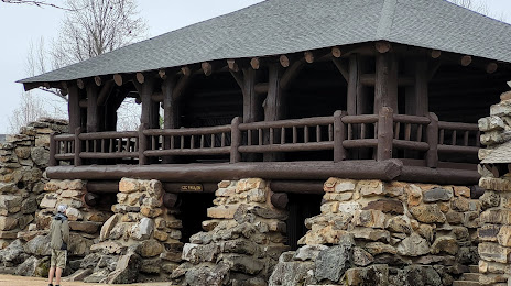
Photo
Where is located Crowley's Ridge State Park
Crowley's Ridge State Park — local attraction, which is located at 2092 AR-168 North, Paragould, AR 72450, United States and belongs to the category — state park. Average visitor rating for this place — 4.7 (according to 140 ratings, information from open sources and relevant for 2022).
Exact location — Crowley's Ridge State Park, marked on the map with a red marker.
You can get directions to Crowley's Ridge State Park on the map from your location.
What else is interesting in Paragould? You can see all the sights if you go to the city page.
Coordinates
Crowley's Ridge State Park, United States coordinates in decimal format: latitude — 36.043325942443886, longitude — -90.66402777518182. When converted to degrees, minutes, seconds Crowley's Ridge State Park has the following coordinates: 36°2′35.97 north latitude and -90°39′50.5 east longitude.
Nearby cities
The largest cities that are located nearby:
- Memphis — 108 km
- Little Rock — 218 km
- Springfield — 277 km
- Clarksville — 284 km
- Saint Louis — 285 km
- Evansville — 331 km
- Nashville — 332 km
- Huntsville — 385 km
- Jackson — 417 km
- Birmingham — 441 km
- Independence — 475 km
- Louisville — 478 km
- Chattanooga — 483 km
- Overland Park — 483 km
- Kansas City — 485 km
- Olathe — 486 km
- North Kansas City — 488 km
- Tulsa — 491 km
- Shreveport — 495 km
Distance to the capital
Distance to the capital (Washington) is about — 1243 km.