 Warner Robins
Wantagh
Bethel
Misty Hill Farm
United States
Wakonda Beach (R33) Airport
Wilmington
Poland
Miami International Airport
Warner Robins
Wantagh
Bethel
Misty Hill Farm
United States
Wakonda Beach (R33) Airport
Wilmington
Poland
Miami International Airport
Magnolia Lane Plantation on the map, Metairie, United States
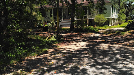
Photo
Where is located Magnolia Lane Plantation
Magnolia Lane Plantation — local attraction, which is located at 2141 River Rd, Nine Mile Point, LA 70094, United States and belongs to the category — historical landmark. Average visitor rating for this place — 4.9 (according to 18 ratings, information from open sources and relevant for 2022).
Exact location — Magnolia Lane Plantation, marked on the map with a red marker.
You can get directions to Magnolia Lane Plantation on the map from your location.
What else is interesting in Metairie? You can see all the sights if you go to the city page.
Coordinates
Magnolia Lane Plantation, United States coordinates in decimal format: latitude — 29.949814449297673, longitude — -90.15339247533768. When converted to degrees, minutes, seconds Magnolia Lane Plantation has the following coordinates: 29°56′59.33 north latitude and -90°9′12.21 east longitude.
Nearby cities
The largest cities that are located nearby:
- New Orleans — 9 km
- Baton Rouge — 108 km
- Lafayette — 180 km
- Mobile — 216 km
- Jackson — 256 km
- Beaumont — 380 km
- Shreveport — 437 km
- Montgomery — 446 km
- Birmingham — 498 km
- Houston — 501 km
- Little Rock — 561 km
- Tallahassee — 562 km
- Memphis — 571 km
- Huntsville — 617 km
- Mesquite — 674 km
- Atlanta — 674 km
- Waco — 681 km
- Garland — 684 km
- Dallas — 691 km
Distance to the capital
Distance to the capital (Washington) is about — 1559 km.