 Warner Robins
Wantagh
Bethel
Misty Hill Farm
United States
Wakonda Beach (R33) Airport
Wilmington
Poland
Miami International Airport
Warner Robins
Wantagh
Bethel
Misty Hill Farm
United States
Wakonda Beach (R33) Airport
Wilmington
Poland
Miami International Airport
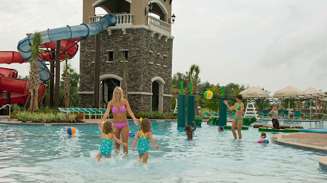
The Waterpark at Riverstone on the map, Sugar Land, United States
Photo
Where is located The Waterpark at Riverstone
The Waterpark at Riverstone — local attraction, which is located at 18353 University Blvd, Sugar Land, TX 77479, United States and belongs to the category — water park. Average visitor rating for this place — 4.1 (according to 76 ratings, information from open sources and relevant for 2022).
Exact location — The Waterpark at Riverstone, marked on the map with a red marker.
You can get directions to The Waterpark at Riverstone on the map from your location.
What else is interesting in Sugar Land? You can see all the sights if you go to the city page.
Coordinates
The Waterpark at Riverstone, United States coordinates in decimal format: latitude — 29.54928538197443, longitude — -95.59332967534702. When converted to degrees, minutes, seconds The Waterpark at Riverstone has the following coordinates: 29°32′57.43 north latitude and -95°35′35.99 east longitude.
Nearby cities
The largest cities that are located nearby:
- Houston — 30 km
- Beaumont — 153 km
- Austin — 214 km
- Waco — 257 km
- Killeen — 258 km
- Corpus Christi — 265 km
- San Antonio — 276 km
- Lafayette — 352 km
- Mesquite — 359 km
- Dallas — 365 km
- Shreveport — 366 km
- Grand Prairie — 368 km
- Arlington — 371 km
- Irving — 374 km
- Garland — 376 km
- Fort Worth — 381 km
- Richardson — 382 km
- Plano — 389 km
- Carrollton — 389 km
Distance to the capital
Distance to the capital (Washington) is about — 1993 km.