 Warner Robins
Wantagh
Bethel
Misty Hill Farm
United States
Wakonda Beach (R33) Airport
Wilmington
Poland
Miami International Airport
Warner Robins
Wantagh
Bethel
Misty Hill Farm
United States
Wakonda Beach (R33) Airport
Wilmington
Poland
Miami International Airport
Point Marion Lock and Dam on the map, Morgantown, United States
Photo
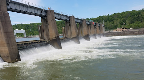
Where is located Point Marion Lock and Dam
Point Marion Lock and Dam — local attraction, which is located at 304 Power Plant Rd, Dilliner, PA 15327, United States and belongs to the category — dam. Average visitor rating for this place — 4.7 (according to 11 ratings, information from open sources and relevant for 2022).
Exact location — Point Marion Lock and Dam, marked on the map with a red marker.
You can get directions to Point Marion Lock and Dam on the map from your location.
What else is interesting in Morgantown? You can see all the sights if you go to the city page.
Coordinates
Point Marion Lock and Dam, United States coordinates in decimal format: latitude — 39.72772344796075, longitude — -79.91270537507546. When converted to degrees, minutes, seconds Point Marion Lock and Dam has the following coordinates: 39°43′39.8 north latitude and -79°54′45.74 east longitude.
Nearby cities
The largest cities that are located nearby:
- Pittsburgh — 90 km
- Akron — 207 km
- Aurora — 219 km
- Cleveland — 252 km
- Columbus — 260 km
- Alexandria — 267 km
- Baltimore — 289 km
- Richmond — 320 km
- Springfield — 328 km
- Boston — 346 km
- Buffalo — 371 km
- Toledo — 373 km
- Amherst — 382 km
- London
 (Canada) — 386 km
 - Windsor (Canada) — 389 km
- Allentown — 390 km
- Winston-Salem — 391 km
- Detroit — 391 km
- Greensboro — 394 km
Distance to the capital
Distance to the capital (Washington) is about — 264 km.