 Warner Robins
Wantagh
Bethel
Misty Hill Farm
United States
Wakonda Beach (R33) Airport
Wilmington
Poland
Miami International Airport
Warner Robins
Wantagh
Bethel
Misty Hill Farm
United States
Wakonda Beach (R33) Airport
Wilmington
Poland
Miami International Airport
Von Schmidt State Boundary Monument on the map, Mohave Valley, United States
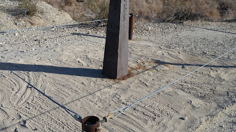
Photo
Where is located Von Schmidt State Boundary Monument
Von Schmidt State Boundary Monument — local attraction, which is located at Milepost 612 of Von Schmidt Line, Von Schmidt Boundary, Needles Hwy, Needles, CA 92363, United States and belongs to the category — monument. Average visitor rating for this place — 4.7 (according to 17 ratings, information from open sources and relevant for 2022).
Exact location — Von Schmidt State Boundary Monument, marked on the map with a red marker.
You can get directions to Von Schmidt State Boundary Monument on the map from your location.
What else is interesting in Mohave Valley? You can see all the sights if you go to the city page.
Coordinates
Von Schmidt State Boundary Monument, United States coordinates in decimal format: latitude — 35.01406703869963, longitude — -114.66177827520988. When converted to degrees, minutes, seconds Von Schmidt State Boundary Monument has the following coordinates: 35°0′50.64 north latitude and -114°39′42.4 east longitude.
Nearby cities
The largest cities that are located nearby:
- Henderson — 127 km
- Spring Valley — 143 km
- Las Vegas — 145 km
- North Las Vegas — 148 km
- Peoria — 263 km
- San Bernardino — 264 km
- Moreno Valley — 266 km
- Mexicali
 (Mexico) — 268 km
 - Glendale — 270 km
- Rialto — 271 km
- San Luis Río Colorado (Mexico) — 275 km
- Fontana — 277 km
- Riverside — 279 km
- Phoenix — 284 km
- Rancho Cucamonga — 290 km
- Scottsdale — 293 km
- Tempe — 296 km
- Ontario — 296 km
- Corona — 297 km
Distance to the capital
Distance to the capital (Washington) is about — 3348 km.