 Warner Robins
Wantagh
Bethel
Misty Hill Farm
United States
Wakonda Beach (R33) Airport
Wilmington
Poland
Miami International Airport
Warner Robins
Wantagh
Bethel
Misty Hill Farm
United States
Wakonda Beach (R33) Airport
Wilmington
Poland
Miami International Airport
St. Mary Help of Christians on the map, Aiken, United States
Photo
Where is located St. Mary Help of Christians
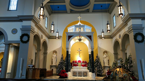
St. Mary Help of Christians — local attraction, which is located at 138 Fairfield St SE, Aiken, SC 29801, United States and belongs to the category — catholic church. Average visitor rating for this place — 4.8 (according to 159 ratings, information from open sources and relevant for 2022).
Exact location — St. Mary Help of Christians, marked on the map with a red marker.
You can get directions to St. Mary Help of Christians on the map from your location.
What else is interesting in Aiken? You can see all the sights if you go to the city page.
Coordinates
St. Mary Help of Christians, United States coordinates in decimal format: latitude — 33.55855014819593, longitude — -81.71684027524847. When converted to degrees, minutes, seconds St. Mary Help of Christians has the following coordinates: 33°33′30.78 north latitude and -81°43′0.62 east longitude.
Nearby cities
The largest cities that are located nearby:
- Columbia — 79 km
- Savannah — 173 km
- Charleston — 187 km
- Charlotte — 201 km
- Atlanta — 246 km
- Fayetteville — 306 km
- Winston-Salem — 310 km
- Greensboro — 327 km
- Knoxville — 330 km
- Jacksonville — 357 km
- Cary — 361 km
- Chattanooga — 364 km
- Durham — 369 km
- Raleigh — 370 km
- Tallahassee — 423 km
- Gainesville — 436 km
- Montgomery — 448 km
- Huntsville — 461 km
- Birmingham — 469 km
Distance to the capital
Distance to the capital (Washington) is about — 728 km.