 Warner Robins
Wantagh
Bethel
Misty Hill Farm
United States
Wakonda Beach (R33) Airport
Wilmington
Poland
Miami International Airport
Warner Robins
Wantagh
Bethel
Misty Hill Farm
United States
Wakonda Beach (R33) Airport
Wilmington
Poland
Miami International Airport
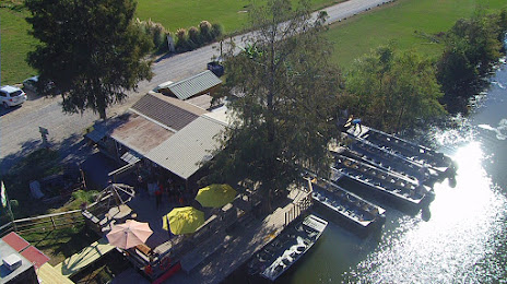
Champagne's Cajun Swamp Tours on the map, Lafayette, United States
Photo
Where is located Champagne's Cajun Swamp Tours
Champagne's Cajun Swamp Tours — local attraction, which is located at 1151 Rookery Rd, Breaux Bridge, LA 70517, United States and belongs to the category — tourist attraction. Average visitor rating for this place — 4.7 (according to 913 ratings, information from open sources and relevant for 2022).
Exact location — Champagne's Cajun Swamp Tours, marked on the map with a red marker.
You can get directions to Champagne's Cajun Swamp Tours on the map from your location.
What else is interesting in Lafayette? You can see all the sights if you go to the city page.
Coordinates
Champagne's Cajun Swamp Tours, United States coordinates in decimal format: latitude — 30.22117526382441, longitude — -91.90354337533128. When converted to degrees, minutes, seconds Champagne's Cajun Swamp Tours has the following coordinates: 30°13′16.23 north latitude and -91°54′12.76 east longitude.
Nearby cities
The largest cities that are located nearby:
- Baton Rouge — 88 km
- Metairie — 181 km
- New Orleans — 189 km
- Beaumont — 202 km
- Jackson — 286 km
- Shreveport — 301 km
- Houston — 326 km
- Mobile — 382 km
- Little Rock — 501 km
- Waco — 505 km
- Mesquite — 510 km
- Garland — 522 km
- Dallas — 526 km
- Richardson — 531 km
- Plano — 533 km
- Irving — 540 km
- Grand Prairie — 540 km
- Carrollton — 545 km
- Austin — 547 km
Distance to the capital
Distance to the capital (Washington) is about — 1666 km.