 Warner Robins
Wantagh
Bethel
Misty Hill Farm
United States
Wakonda Beach (R33) Airport
Wilmington
Poland
Miami International Airport
Warner Robins
Wantagh
Bethel
Misty Hill Farm
United States
Wakonda Beach (R33) Airport
Wilmington
Poland
Miami International Airport
Clark County Historical Museum on the map, Arkadelphia, United States
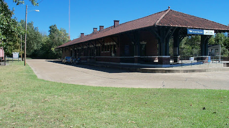
Photo
Where is located Clark County Historical Museum
Clark County Historical Museum — local attraction, which is located at 750 S 5th St, Arkadelphia, AR 71923, United States and belongs to the category — local history museum. Average visitor rating for this place — 4.8 (according to 8 ratings, information from open sources and relevant for 2022).
Exact location — Clark County Historical Museum, marked on the map with a red marker.
You can get directions to Clark County Historical Museum on the map from your location.
What else is interesting in Arkadelphia? You can see all the sights if you go to the city page.
Coordinates
Clark County Historical Museum, United States coordinates in decimal format: latitude — 34.114143708726296, longitude — -93.05309727523394. When converted to degrees, minutes, seconds Clark County Historical Museum has the following coordinates: 34°6′50.92 north latitude and -93°3′11.15 east longitude.
Nearby cities
The largest cities that are located nearby:
- Little Rock — 98 km
- Shreveport — 188 km
- Memphis — 294 km
- Jackson — 335 km
- Springfield — 342 km
- Tulsa — 345 km
- Garland — 359 km
- Plano — 359 km
- Mesquite — 362 km
- Richardson — 365 km
- Frisco — 365 km
- Carrollton — 378 km
- Dallas — 378 km
- Irving — 390 km
- Denton — 390 km
- Grand Prairie — 397 km
- Arlington — 407 km
- Norman — 414 km
- Fort Worth — 425 km
Distance to the capital
Distance to the capital (Washington) is about — 1525 km.