 Warner Robins
Wantagh
Bethel
Misty Hill Farm
United States
Wakonda Beach (R33) Airport
Wilmington
Poland
Miami International Airport
Warner Robins
Wantagh
Bethel
Misty Hill Farm
United States
Wakonda Beach (R33) Airport
Wilmington
Poland
Miami International Airport
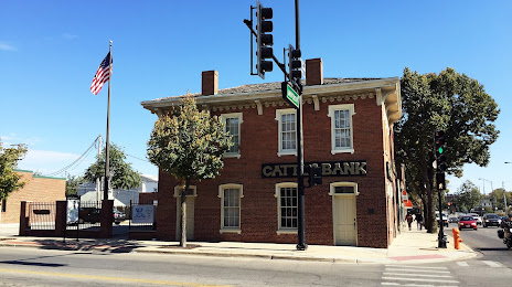
Champaign County History Museum at the Historic Cattle Bank on the map, Champaign, United States
Photo
Where is located Champaign County History Museum at the Historic Cattle Bank
Champaign County History Museum at the Historic Cattle Bank — local attraction, which is located at 102 E University Ave, Champaign, IL 61820, United States and belongs to the category — museum. Average visitor rating for this place — 4.9 (according to 8 ratings, information from open sources and relevant for 2022).
Exact location — Champaign County History Museum at the Historic Cattle Bank, marked on the map with a red marker.
You can get directions to Champaign County History Museum at the Historic Cattle Bank on the map from your location.
What else is interesting in Champaign? You can see all the sights if you go to the city page.
Coordinates
Champaign County History Museum at the Historic Cattle Bank, United States coordinates in decimal format: latitude — 40.11647695813315, longitude — -88.2385560750638. When converted to degrees, minutes, seconds Champaign County History Museum at the Historic Cattle Bank has the following coordinates: 40°6′59.32 north latitude and -88°14′18.8 east longitude.
Nearby cities
The largest cities that are located nearby:
- Peoria — 130 km
- Joliet — 156 km
- Naperville — 181 km
- Indianapolis — 181 km
- Aurora — 182 km
- Chicago — 201 km
- Saint Louis — 236 km
- South Bend — 238 km
- Evansville — 244 km
- Rockford — 248 km
- Fort Wayne — 280 km
- Louisville — 298 km
- Milwaukee — 324 km
- Cincinnati — 339 km
- Madison — 340 km
- Springfield — 377 km
- Grand Rapids — 377 km
- Clarksville — 404 km
- Lansing — 416 km
Distance to the capital
Distance to the capital (Washington) is about — 970 km.