 Warner Robins
Wantagh
Bethel
Misty Hill Farm
United States
Wakonda Beach (R33) Airport
Wilmington
Poland
Miami International Airport
Warner Robins
Wantagh
Bethel
Misty Hill Farm
United States
Wakonda Beach (R33) Airport
Wilmington
Poland
Miami International Airport
Indian and Colonial Research Center on the map, Groton, United States
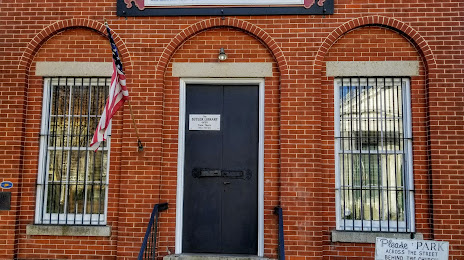
Photo
Where is located Indian and Colonial Research Center
Indian and Colonial Research Center — local attraction, which is located at 39 Main St, Old Mystic, CT 06372, United States and belongs to the category — local history museum. Average visitor rating for this place — 5.0 (according to 2 ratings, information from open sources and relevant for 2022).
Exact location — Indian and Colonial Research Center, marked on the map with a red marker.
You can get directions to Indian and Colonial Research Center on the map from your location.
What else is interesting in Groton? You can see all the sights if you go to the city page.
Coordinates
Indian and Colonial Research Center, United States coordinates in decimal format: latitude — 41.390231558647656, longitude — -71.9602239750247. When converted to degrees, minutes, seconds Indian and Colonial Research Center has the following coordinates: 41°23′24.83 north latitude and -71°57′36.81 east longitude.
Nearby cities
The largest cities that are located nearby:
- Hartford — 68 km
- New Haven — 71 km
- Providence — 76 km
- Waterbury — 84 km
- Springfield — 93 km
- Bridgeport — 95 km
- Worcester — 103 km
- Amherst — 115 km
- Stamford — 126 km
- Cambridge — 138 km
- Boston — 139 km
- Lowell — 155 km
- Yonkers — 159 km
- Brooklyn — 176 km
- New York — 176 km
- Paterson — 181 km
- Newark — 188 km
- Manchester — 189 km
- Elizabeth — 194 km
Distance to the capital
Distance to the capital (Washington) is about — 512 km.