 Warner Robins
Wantagh
Bethel
Misty Hill Farm
United States
Wakonda Beach (R33) Airport
Wilmington
Poland
Miami International Airport
Warner Robins
Wantagh
Bethel
Misty Hill Farm
United States
Wakonda Beach (R33) Airport
Wilmington
Poland
Miami International Airport
Dunkirk Lighthouse on the map, Fredonia, United States
Photo
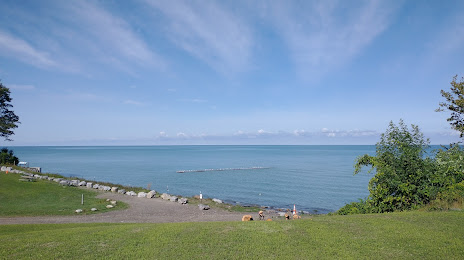
Where is located Dunkirk Lighthouse
Dunkirk Lighthouse — local attraction, which is located at no data and belongs to the category — -. Average visitor rating for this place — 4.6 (according to 505 ratings, information from open sources and relevant for 2022).
Exact location — Dunkirk Lighthouse, marked on the map with a red marker.
You can get directions to Dunkirk Lighthouse on the map from your location.
What else is interesting in Fredonia? You can see all the sights if you go to the city page.
Coordinates
Dunkirk Lighthouse, United States coordinates in decimal format: latitude — 42.44007204820386, longitude — -79.33261532553114. When converted to degrees, minutes, seconds Dunkirk Lighthouse has the following coordinates: 42°26′24.26 north latitude and -79°19′57.42 east longitude.
Nearby cities
The largest cities that are located nearby:
- Boston — 53 km
- Buffalo — 62 km
- Amherst — 74 km
- Saint Catharines
 (Canada) — 80 km
 - Hamilton (Canada) — 99 km
- Burlington (Canada) — 105 km
- Oakville (Canada) — 117 km
- Cambridge (Canada) — 129 km
- Mississauga (Canada) — 129 km
- Toronto (Canada) — 134 km
- Kitchener (Canada) — 142 km
- Guelph (Canada) — 143 km
- Brampton (Canada) — 147 km
- Waterloo (Canada) — 148 km
- Vaughan (Canada) — 155 km
- Markham (Canada) — 157 km
- Richmond Hill (Canada) — 160 km
- Rochester — 160 km
- Whitby (Canada) — 164 km
Distance to the capital
Distance to the capital (Washington) is about — 438 km.