 Warner Robins
Wantagh
Bethel
Misty Hill Farm
United States
Wakonda Beach (R33) Airport
Wilmington
Poland
Miami International Airport
Warner Robins
Wantagh
Bethel
Misty Hill Farm
United States
Wakonda Beach (R33) Airport
Wilmington
Poland
Miami International Airport
Saluda Shoals Park on the map, West Columbia, United States
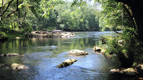
Photo
Where is located Saluda Shoals Park
Saluda Shoals Park — local attraction, which is located at 5605 Bush River Rd, Columbia, SC 29212, United States and belongs to the category — park. Average visitor rating for this place — 4.7 (according to 735 ratings, information from open sources and relevant for 2022).
Exact location — Saluda Shoals Park, marked on the map with a red marker.
You can get directions to Saluda Shoals Park on the map from your location.
What else is interesting in West Columbia? You can see all the sights if you go to the city page.
Coordinates
Saluda Shoals Park, United States coordinates in decimal format: latitude — 34.05358268014443, longitude — -81.16003647523553. When converted to degrees, minutes, seconds Saluda Shoals Park has the following coordinates: 34°3′12.9 north latitude and -81°9′36.13 east longitude.
Nearby cities
The largest cities that are located nearby:
- Columbia — 4 km
- Charlotte — 138 km
- Charleston — 171 km
- Savannah — 211 km
- Fayetteville — 231 km
- Winston-Salem — 244 km
- Greensboro — 257 km
- Cary — 286 km
- Raleigh — 295 km
- Durham — 295 km
- Atlanta — 306 km
- Knoxville — 335 km
- Chattanooga — 401 km
- Jacksonville — 409 km
- Gainesville — 495 km
- Tallahassee — 498 km
- Richmond — 505 km
- Huntsville — 507 km
- Montgomery — 520 km
Distance to the capital
Distance to the capital (Washington) is about — 654 km.