 Warner Robins
Wantagh
Bethel
Misty Hill Farm
United States
Wakonda Beach (R33) Airport
Wilmington
Poland
Miami International Airport
Warner Robins
Wantagh
Bethel
Misty Hill Farm
United States
Wakonda Beach (R33) Airport
Wilmington
Poland
Miami International Airport
Deep Fork National Wildlife Refuge on the map, Okmulgee, United States
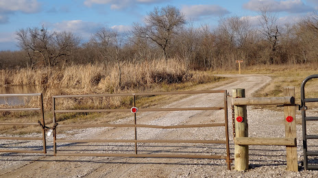
Photo
Where is located Deep Fork National Wildlife Refuge
Deep Fork National Wildlife Refuge — local attraction, which is located at 21844 S 250 Rd, Henryetta, OK 74437, United States and belongs to the category — wildlife refuge. Average visitor rating for this place — 4.8 (according to 24 ratings, information from open sources and relevant for 2022).
Exact location — Deep Fork National Wildlife Refuge, marked on the map with a red marker.
You can get directions to Deep Fork National Wildlife Refuge on the map from your location.
What else is interesting in Okmulgee? You can see all the sights if you go to the city page.
Coordinates
Deep Fork National Wildlife Refuge, United States coordinates in decimal format: latitude — 35.53844699375636, longitude — -95.92762037519566. When converted to degrees, minutes, seconds Deep Fork National Wildlife Refuge has the following coordinates: 35°32′18.41 north latitude and -95°55′39.43 east longitude.
Nearby cities
The largest cities that are located nearby:
- Tulsa — 59 km
- Norman — 141 km
- Oklahoma City — 141 km
- Wichita — 258 km
- Frisco — 285 km
- Denton — 288 km
- Springfield — 293 km
- Plano — 296 km
- Wichita Falls — 300 km
- Richardson — 304 km
- Carrollton — 305 km
- Garland — 306 km
- Mesquite — 321 km
- Irving — 324 km
- Dallas — 324 km
- Grand Prairie — 332 km
- Arlington — 337 km
- Fort Worth — 342 km
- Little Rock — 347 km
Distance to the capital
Distance to the capital (Washington) is about — 1711 km.