 Warner Robins
Wantagh
Bethel
Misty Hill Farm
United States
Wakonda Beach (R33) Airport
Wilmington
Poland
Miami International Airport
Warner Robins
Wantagh
Bethel
Misty Hill Farm
United States
Wakonda Beach (R33) Airport
Wilmington
Poland
Miami International Airport
Audrain County Historical Society on the map, Mexico, United States
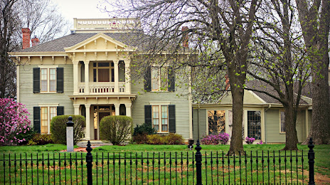
Photo
Where is located Audrain County Historical Society
Audrain County Historical Society — local attraction, which is located at 501 S Muldrow St, Mexico, MO 65265, United States and belongs to the category — museum. Average visitor rating for this place — 4.7 (according to 6 ratings, information from open sources and relevant for 2022).
Exact location — Audrain County Historical Society, marked on the map with a red marker.
You can get directions to Audrain County Historical Society on the map from your location.
What else is interesting in Mexico? You can see all the sights if you go to the city page.
Coordinates
Audrain County Historical Society, United States coordinates in decimal format: latitude — 39.16835154855528, longitude — -91.8895803750922. When converted to degrees, minutes, seconds Audrain County Historical Society has the following coordinates: 39°10′6.07 north latitude and -91°53′22.49 east longitude.
Nearby cities
The largest cities that are located nearby:
- Saint Louis — 158 km
- Independence — 217 km
- North Kansas City — 230 km
- Kansas City — 231 km
- Overland Park — 240 km
- Springfield — 250 km
- Olathe — 254 km
- Peoria — 256 km
- Des Moines — 304 km
- Topeka — 327 km
- Evansville — 399 km
- Joliet — 408 km
- Aurora — 410 km
- Rockford — 412 km
- Omaha — 412 km
- Naperville — 420 km
- Lincoln — 441 km
- Chicago — 461 km
- Memphis — 475 km
Distance to the capital
Distance to the capital (Washington) is about — 1282 km.