 Warner Robins
Wantagh
Bethel
Misty Hill Farm
United States
Wakonda Beach (R33) Airport
Wilmington
Poland
Miami International Airport
Warner Robins
Wantagh
Bethel
Misty Hill Farm
United States
Wakonda Beach (R33) Airport
Wilmington
Poland
Miami International Airport
Arroyo Trails on the map, Channahon, United States
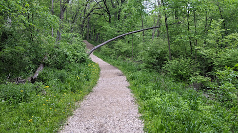
Photo
Where is located Arroyo Trails
Arroyo Trails — local attraction, which is located at 24856 W Eames St, Channahon, IL 60410, United States and belongs to the category — park. Average visitor rating for this place — 4.4 (according to 81 rating, information from open sources and relevant for 2022).
Exact location — Arroyo Trails, marked on the map with a red marker.
You can get directions to Arroyo Trails on the map from your location.
What else is interesting in Channahon? You can see all the sights if you go to the city page.
Coordinates
Arroyo Trails, United States coordinates in decimal format: latitude — 41.4246274778144, longitude — -88.23705487502365. When converted to degrees, minutes, seconds Arroyo Trails has the following coordinates: 41°25′28.66 north latitude and -88°14′13.4 east longitude.
Nearby cities
The largest cities that are located nearby:
- Joliet — 16 km
- Naperville — 36 km
- Aurora — 37 km
- Chicago — 70 km
- Rockford — 117 km
- Peoria — 140 km
- South Bend — 166 km
- Milwaukee — 180 km
- Madison — 205 km
- Indianapolis — 254 km
- Fort Wayne — 260 km
- Grand Rapids — 268 km
- Lansing — 331 km
- Green Bay — 342 km
- Saint Louis — 354 km
- Ann Arbor — 379 km
- Evansville — 387 km
- Toledo — 387 km
- Flint — 407 km
Distance to the capital
Distance to the capital (Washington) is about — 991 km.