 Warner Robins
Wantagh
Bethel
Misty Hill Farm
United States
Wakonda Beach (R33) Airport
Wilmington
Poland
Miami International Airport
Warner Robins
Wantagh
Bethel
Misty Hill Farm
United States
Wakonda Beach (R33) Airport
Wilmington
Poland
Miami International Airport
Brown County Historical Society on the map, New Ulm, United States
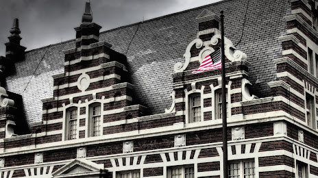
Photo
Where is located Brown County Historical Society
Brown County Historical Society — local attraction, which is located at 2 N Broadway St, New Ulm, MN 56073, United States and belongs to the category — museum. Average visitor rating for this place — 4.6 (according to 33 ratings, information from open sources and relevant for 2022).
Exact location — Brown County Historical Society, marked on the map with a red marker.
You can get directions to Brown County Historical Society on the map from your location.
What else is interesting in New Ulm? You can see all the sights if you go to the city page.
Coordinates
Brown County Historical Society, United States coordinates in decimal format: latitude — 44.31291733324294, longitude — -94.4602986749313. When converted to degrees, minutes, seconds Brown County Historical Society has the following coordinates: 44°18′46.5 north latitude and -94°27′37.08 east longitude.
Nearby cities
The largest cities that are located nearby:
- Minneapolis — 119 km
- Saint Paul — 128 km
- Sioux Falls — 201 km
- Des Moines — 308 km
- Omaha — 362 km
- Lincoln — 428 km
- Madison — 431 km
- Rockford — 494 km
- Green Bay — 508 km
- Milwaukee — 548 km
- Peoria — 572 km
- North Kansas City — 572 km
- Kansas City — 577 km
- Independence — 577 km
- Aurora — 580 km
- Overland Park — 590 km
- Topeka — 591 km
- Naperville — 592 km
- Olathe — 601 km
Distance to the capital
Distance to the capital (Washington) is about — 1565 km.